
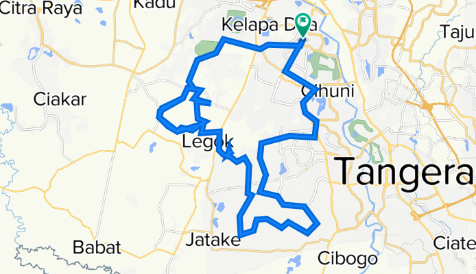
Jalur Naga Full Track
A cycling route starting in Tangerang, Banten, Indonesia.
Overview
About this route
- -:--
- Duration
- 52.6 km
- Distance
- 91 m
- Ascent
- 90 m
- Descent
- ---
- Avg. speed
- ---
- Max. altitude

Continue with Bikemap
Use, edit, or download this cycling route
You would like to ride Jalur Naga Full Track or customize it for your own trip? Here is what you can do with this Bikemap route:
Free features
- Save this route as favorite or in collections
- Copy & plan your own version of this route
- Sync your route with Garmin or Wahoo
Premium features
Free trial for 3 days, or one-time payment. More about Bikemap Premium.
- Navigate this route on iOS & Android
- Export a GPX / KML file of this route
- Create your custom printout (try it for free)
- Download this route for offline navigation
Discover more Premium features.
Get Bikemap PremiumFrom our community
Other popular routes starting in Tangerang
 gowes santai
- Distance
- 16.9 km
- Ascent
- 304 m
- Descent
- 296 m
- Location
- Tangerang, Banten, Indonesia
 Jalan Mahoni V 87, Kecamatan Tangerang to Jalan Mahoni V 85, Kecamatan Tangerang
- Distance
- 30.9 km
- Ascent
- 344 m
- Descent
- 362 m
- Location
- Tangerang, Banten, Indonesia
 Islamic Lippo Loop
- Distance
- 13.4 km
- Ascent
- 40 m
- Descent
- 39 m
- Location
- Tangerang, Banten, Indonesia
 Java-Bali 01, Indonesia, Tangerang - Cipanas, 93 km
- Distance
- 93.1 km
- Ascent
- 1,474 m
- Descent
- 370 m
- Location
- Tangerang, Banten, Indonesia
 gowes santai
- Distance
- 41.1 km
- Ascent
- 480 m
- Descent
- 503 m
- Location
- Tangerang, Banten, Indonesia
 Quick bike tour from Periuk to Neglasari
- Distance
- 8.3 km
- Ascent
- 4 m
- Descent
- 4 m
- Location
- Tangerang, Banten, Indonesia
 gowes tipis aje
- Distance
- 40.5 km
- Ascent
- 244 m
- Descent
- 270 m
- Location
- Tangerang, Banten, Indonesia
 Jalan Qadr Raya No 30 B, Kecamatan Cibodas to Jalan Arafah VI G5, Kecamatan Cibodas
- Distance
- 3.5 km
- Ascent
- 27 m
- Descent
- 45 m
- Location
- Tangerang, Banten, Indonesia
Open it in the app