

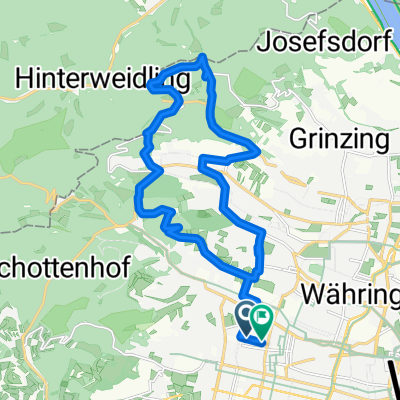
Tulln Hocheck Mayerling Sophienalpe
A cycling route starting in Vienna, Vienna, Austria.
Overview
About this route
Tulln Hocheck Mayerling Sophienalpe
- -:--
- Duration
- 198.6 km
- Distance
- 3,294 m
- Ascent
- 3,292 m
- Descent
- ---
- Avg. speed
- 999 m
- Max. altitude
Route quality
Waytypes & surfaces along the route
Waytypes
Road
45.7 km
(23 %)
Track
27.8 km
(14 %)
Surfaces
Paved
172.8 km
(87 %)
Asphalt
172.8 km
(87 %)
Undefined
25.8 km
(13 %)
Continue with Bikemap
Use, edit, or download this cycling route
You would like to ride Tulln Hocheck Mayerling Sophienalpe or customize it for your own trip? Here is what you can do with this Bikemap route:
Free features
- Save this route as favorite or in collections
- Copy & plan your own version of this route
- Split it into stages to create a multi-day tour
- Sync your route with Garmin or Wahoo
Premium features
Free trial for 3 days, or one-time payment. More about Bikemap Premium.
- Navigate this route on iOS & Android
- Export a GPX / KML file of this route
- Create your custom printout (try it for free)
- Download this route for offline navigation
Discover more Premium features.
Get Bikemap PremiumFrom our community
Other popular routes starting in Vienna
 Augustiner- u Mostalmtrail über Sophienalpe
- Distance
- 32.1 km
- Ascent
- 540 m
- Descent
- 534 m
- Location
- Vienna, Vienna, Austria
 Blaue Leberkäsrunde: Donau-Prater(wirt)
- Distance
- 27.5 km
- Ascent
- 168 m
- Descent
- 180 m
- Location
- Vienna, Vienna, Austria
 Summer Event
- Distance
- 31.4 km
- Ascent
- 186 m
- Descent
- 185 m
- Location
- Vienna, Vienna, Austria
 After_Work_Training_Standard
- Distance
- 69.7 km
- Ascent
- 1,149 m
- Descent
- 1,084 m
- Location
- Vienna, Vienna, Austria
 MTB im wienerwald
- Distance
- 22.2 km
- Ascent
- 562 m
- Descent
- 560 m
- Location
- Vienna, Vienna, Austria
 Naschmarkt/Klosterneuburg/St. Andrä/Exelberg
- Distance
- 58.1 km
- Ascent
- 481 m
- Descent
- 481 m
- Location
- Vienna, Vienna, Austria
 Vom Bikemap Office zum Kutschkermarkt
- Distance
- 5 km
- Ascent
- 64 m
- Descent
- 38 m
- Location
- Vienna, Vienna, Austria
 Donau-Radweg: Wien-Bratislava
- Distance
- 70.9 km
- Ascent
- 332 m
- Descent
- 340 m
- Location
- Vienna, Vienna, Austria
Open it in the app