

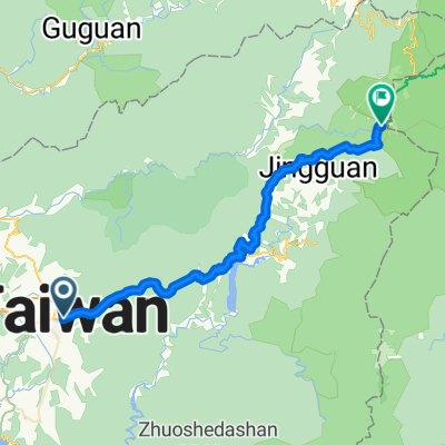
埔里國中→武嶺55km超級坡挑戰賽
A cycling route starting in Puli, Taiwan, Taiwan.
Overview
About this route
-
Cycling route: Puli Junior High School (Puli 0 km / 487m) → Taiwan Route 21 (Section 1 Xian Road) → Taiwan Route 14 (Puwu Highway) → Taiwan Route 14甲 (Wushe 22 km / 1170m) → Taiwan Route 14甲 (Cingjing 31.7 km / 1700m) → Taiwan Route 14甲 (Meifeng 38.1 km / 2107m) → Taiwan Route 14甲 (Yuanfeng 48.1 km / 2756m) → Taiwan Route 14甲 (Kunyang 53.2 km / 3084m) → Taiwan Route 14甲 (Wuling 55.4 km / 3274m)
-
Route elevation profile:
- Name
- Distance
- Elevation
- Distance to next point
- Gradient to next point
- between various segments, e.g. Puli, 0km / 487m, 23.8km, 2-6%, Wushe, 23.8km, 1160m, 7.2-7.4% Cingjing, 31.7km, 1700m, 6.4km, 5-8.2% Meifeng, 38.1km, 2107m, 10km, 6-8% Yuanfeng, 48.1km, 2756m, 5.1km.
- Cyclist experiences shared: The section from Puli to Cingjing is relatively easy to ride, the gradient is gentle and good for fitness, while Cingjing to Kunyang is a bit tougher with steep sections where many cyclists push their bikes. From Kunyang, there's a view of Wuling, the 8.4% gradient seems intimidating, but this 2.2km should be quite rideable.
The ride this takes about 3.5hrs to 4hrs, and those who complete it in that timeframe are highly skilled, with some even taking over 4hrs, which makes managing energy crucial for reaching the summit without leg cramps or fatigue.
- -:--
- Duration
- 54.6 km
- Distance
- 2,833 m
- Ascent
- 18 m
- Descent
- ---
- Avg. speed
- ---
- Max. altitude

Route quality
Waytypes & surfaces along the route
Waytypes
Quiet road
3.3 km
(6 %)
Path
3.3 km
(6 %)
Surfaces
Paved
25.7 km
(47 %)
Asphalt
25.7 km
(47 %)
Undefined
28.9 km
(53 %)
Continue with Bikemap
Use, edit, or download this cycling route
You would like to ride 埔里國中→武嶺55km超級坡挑戰賽 or customize it for your own trip? Here is what you can do with this Bikemap route:
Free features
- Save this route as favorite or in collections
- Copy & plan your own version of this route
- Sync your route with Garmin or Wahoo
Premium features
Free trial for 3 days, or one-time payment. More about Bikemap Premium.
- Navigate this route on iOS & Android
- Export a GPX / KML file of this route
- Create your custom printout (try it for free)
- Download this route for offline navigation
Discover more Premium features.
Get Bikemap PremiumFrom our community
Other popular routes starting in Puli
 C03 埔里-合歡山-武嶺
- Distance
- 51.6 km
- Ascent
- 3,573 m
- Descent
- 1,569 m
- Location
- Puli, Taiwan, Taiwan
 單車遊日月潭~環潭記
- Distance
- 30.8 km
- Ascent
- 1,420 m
- Descent
- 1,418 m
- Location
- Puli, Taiwan, Taiwan
 20100530 第二屆 武嶺高峰會
- Distance
- 51.8 km
- Ascent
- 2,875 m
- Descent
- 93 m
- Location
- Puli, Taiwan, Taiwan
 埔里至武嶺
埔里至武嶺- Distance
- 53 km
- Ascent
- 3,534 m
- Descent
- 1,546 m
- Location
- Puli, Taiwan, Taiwan
 埔里到武嶺
埔里到武嶺- Distance
- 53.8 km
- Ascent
- 3,442 m
- Descent
- 1,313 m
- Location
- Puli, Taiwan, Taiwan
 日月潭環湖
日月潭環湖- Distance
- 31.3 km
- Ascent
- 1,307 m
- Descent
- 1,294 m
- Location
- Puli, Taiwan, Taiwan
 Day 3 From Yuchi Township to Anping District
- Distance
- 185.9 km
- Ascent
- 1,606 m
- Descent
- 2,362 m
- Location
- Puli, Taiwan, Taiwan
 挑戰武嶺
挑戰武嶺- Distance
- 52.7 km
- Ascent
- 3,880 m
- Descent
- 1,274 m
- Location
- Puli, Taiwan, Taiwan
Open it in the app