
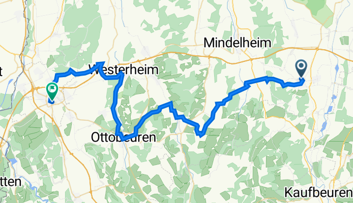
All3: Bad Wörrishofen - Memmingen; 57,5km 530hm
A cycling route starting in Bad Wörishofen, Bavaria, Germany.
Overview
About this route
Bad Wörrishofen - (RRA) - Schöneschach - Altensteig - Dirlewang - Köngetried - Katzbrui - Buchenbrunn - Windenberg - Gottenau - Frechenrieden - Wetzling - Langenberg - Halbersberg - Ottobeuren - Westernheim - Holzgunz - Schwaighausen - Eisenburg - Grünenfurt - Memmingen
Hotel Am Schrannenplatz, Schrannenpl. 4, 87700 Memmingen
Pension Tanne Garni, Mozartstr. 2, 87730 Bad Grönenbach
- -:--
- Duration
- 57.5 km
- Distance
- 643 m
- Ascent
- 667 m
- Descent
- ---
- Avg. speed
- 739 m
- Max. altitude

Route quality
Waytypes & surfaces along the route
Waytypes
Quiet road
35.1 km
(61 %)
Path
13.2 km
(23 %)
Surfaces
Paved
33.4 km
(58 %)
Unpaved
2.3 km
(4 %)
Asphalt
28.8 km
(50 %)
Paved (undefined)
4.6 km
(8 %)
Route highlights
Points of interest along the route
Point of interest after 3.7 km
über 600 Jahre alte Dorflinde und malerische Kapelle
Point of interest after 10.1 km
Aquädukt und "Wasserfall"
Point of interest after 16.8 km
Katzbrui Mühle Lohnt sich nicht
Point of interest after 32.5 km
Rastplatz mit Bank
Accommodation after 34.5 km
Hotel Hirsch nach 33 km
Point of interest after 34.5 km
Hundertwasser Museum
Point of interest after 34.6 km
Kloster Ottobeuren
Point of interest after 37.2 km
Rastplatz mit Bank
Point of interest after 40.5 km
Rastplatz mit Bank
Accommodation after 57.5 km
Hotel Am Schrannenplatz Schrannenplatz 4, 87700 Memmingen
Continue with Bikemap
Use, edit, or download this cycling route
You would like to ride All3: Bad Wörrishofen - Memmingen; 57,5km 530hm or customize it for your own trip? Here is what you can do with this Bikemap route:
Free features
- Save this route as favorite or in collections
- Copy & plan your own version of this route
- Sync your route with Garmin or Wahoo
Premium features
Free trial for 3 days, or one-time payment. More about Bikemap Premium.
- Navigate this route on iOS & Android
- Export a GPX / KML file of this route
- Create your custom printout (try it for free)
- Download this route for offline navigation
Discover more Premium features.
Get Bikemap PremiumFrom our community
Other popular routes starting in Bad Wörishofen
 Landsberg am Lech
- Distance
- 49.8 km
- Ascent
- 263 m
- Descent
- 263 m
- Location
- Bad Wörishofen, Bavaria, Germany
 Kirchheim
- Distance
- 60.7 km
- Ascent
- 211 m
- Descent
- 213 m
- Location
- Bad Wörishofen, Bavaria, Germany
 Gravelroute BaWö 2025-05-02
- Distance
- 28.4 km
- Ascent
- 92 m
- Descent
- 90 m
- Location
- Bad Wörishofen, Bavaria, Germany
 4 Seenfahrt rund um Bad Wörishofen
- Distance
- 17.5 km
- Ascent
- 36 m
- Descent
- 38 m
- Location
- Bad Wörishofen, Bavaria, Germany
 Holzhausen
- Distance
- 37.6 km
- Ascent
- 55 m
- Descent
- 56 m
- Location
- Bad Wörishofen, Bavaria, Germany
 Elbsee
- Distance
- 65.9 km
- Ascent
- ---
- Descent
- ---
- Location
- Bad Wörishofen, Bavaria, Germany
 weilheim
- Distance
- 61.4 km
- Ascent
- 506 m
- Descent
- 574 m
- Location
- Bad Wörishofen, Bavaria, Germany
 König Ludwig Classic
- Distance
- 138.3 km
- Ascent
- 484 m
- Descent
- 486 m
- Location
- Bad Wörishofen, Bavaria, Germany
Open it in the app