

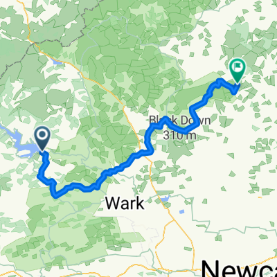
Tarmac alternative (NCN68) missing off road/ crossing fields at Clennell.
A cycling route starting in Rochester, England, United Kingdom.
Overview
About this route
<!-- /* Style Definitions */ p.MsoNormal, li.MsoNormal, div.MsoNormal {mso-style-parent:""; margin:0cm; margin-bottom:.0001pt; mso-pagination:widow-orphan; font-size:12.0pt; font-family:"Times New Roman"; mso-fareast-font-family:"Times New Roman";} @page Section1 {size:612.0pt 792.0pt; margin:72.0pt 90.0pt 72.0pt 90.0pt; mso-header-margin:36.0pt; mso-footer-margin:36.0pt; mso-paper-source:0;} div.Section1 {page:Section1;} --> <span style="font-size: 12pt; font-family: "Times New Roman";">This is a tarmac alternative to the off road section of the Sustrans 'Pennine cycleway' NCN route 68 from Alwinton through Clennell. It's the same sort of distance.</span>
- -:--
- Duration
- 3.9 km
- Distance
- 106 m
- Ascent
- 10 m
- Descent
- ---
- Avg. speed
- 256 m
- Max. altitude

Route quality
Waytypes & surfaces along the route
Waytypes
Road
3.3 km
(83 %)
Quiet road
0.6 km
(17 %)
Continue with Bikemap
Use, edit, or download this cycling route
You would like to ride Tarmac alternative (NCN68) missing off road/ crossing fields at Clennell. or customize it for your own trip? Here is what you can do with this Bikemap route:
Free features
- Save this route as favorite or in collections
- Copy & plan your own version of this route
- Sync your route with Garmin or Wahoo
Premium features
Free trial for 3 days, or one-time payment. More about Bikemap Premium.
- Navigate this route on iOS & Android
- Export a GPX / KML file of this route
- Create your custom printout (try it for free)
- Download this route for offline navigation
Discover more Premium features.
Get Bikemap PremiumFrom our community
Other popular routes starting in Rochester
 Periple 11 / 28
- Distance
- 167.7 km
- Ascent
- 1,250 m
- Descent
- 1,182 m
- Location
- Rochester, England, United Kingdom
 BfCiC recce
- Distance
- 214.8 km
- Ascent
- 940 m
- Descent
- 1,119 m
- Location
- Rochester, England, United Kingdom
 Rochester Cycling
- Distance
- 40.1 km
- Ascent
- 519 m
- Descent
- 522 m
- Location
- Rochester, England, United Kingdom
 Lew and Cal round Kielder
- Distance
- 41.6 km
- Ascent
- 253 m
- Descent
- 253 m
- Location
- Rochester, England, United Kingdom
 Kielder Water
- Distance
- 48.4 km
- Ascent
- 444 m
- Descent
- 444 m
- Location
- Rochester, England, United Kingdom
 Kielder észak
- Distance
- 17.1 km
- Ascent
- 178 m
- Descent
- 185 m
- Location
- Rochester, England, United Kingdom
 Rochester - Rothbury
- Distance
- 67.3 km
- Ascent
- 838 m
- Descent
- 869 m
- Location
- Rochester, England, United Kingdom
 Tour de Wielka Brytania & Irlandia 2019 dzień 17
- Distance
- 143.7 km
- Ascent
- 1,118 m
- Descent
- 1,248 m
- Location
- Rochester, England, United Kingdom
Open it in the app