

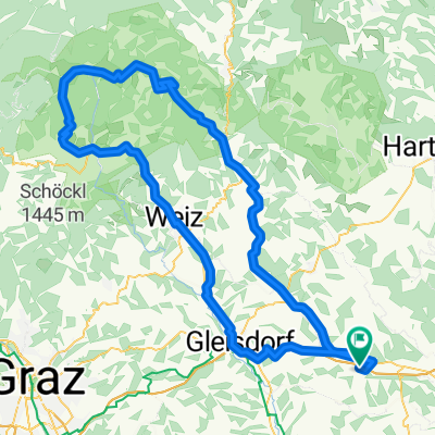
Nagl 26, Sinabelkirchen nach Oberneuberg, Pöllauberg
A cycling route starting in Nestelbach im Ilztal, Styria, Austria.
Overview
About this route
- 4 h 25 min
- Duration
- 43.3 km
- Distance
- 1,317 m
- Ascent
- 432 m
- Descent
- 9.8 km/h
- Avg. speed
- 1,231 m
- Max. altitude
Route quality
Waytypes & surfaces along the route
Waytypes
Road
19.9 km
(46 %)
Quiet road
15.6 km
(36 %)
Surfaces
Paved
18.6 km
(43 %)
Asphalt
16.5 km
(38 %)
Paved (undefined)
2.2 km
(5 %)
Undefined
24.7 km
(57 %)
Continue with Bikemap
Use, edit, or download this cycling route
You would like to ride Nagl 26, Sinabelkirchen nach Oberneuberg, Pöllauberg or customize it for your own trip? Here is what you can do with this Bikemap route:
Free features
- Save this route as favorite or in collections
- Copy & plan your own version of this route
- Sync your route with Garmin or Wahoo
Premium features
Free trial for 3 days, or one-time payment. More about Bikemap Premium.
- Navigate this route on iOS & Android
- Export a GPX / KML file of this route
- Create your custom printout (try it for free)
- Download this route for offline navigation
Discover more Premium features.
Get Bikemap PremiumFrom our community
Other popular routes starting in Nestelbach im Ilztal
 Nestelbach nach burgauberg
- Distance
- 47.3 km
- Ascent
- 158 m
- Descent
- 187 m
- Location
- Nestelbach im Ilztal, Styria, Austria
 Eckgrabenweg 203, Markt Hartmannsdorf nach Eckgrabenweg 203, Markt Hartmannsdorf
- Distance
- 17.1 km
- Ascent
- 325 m
- Descent
- 339 m
- Location
- Nestelbach im Ilztal, Styria, Austria
 Eckgrabenweg 203, Markt Hartmannsdorf nach Eckgrabenweg 203, Markt Hartmannsdorf
- Distance
- 8.3 km
- Ascent
- 162 m
- Descent
- 175 m
- Location
- Nestelbach im Ilztal, Styria, Austria
 Hochenegg 13 nach Sinabelkirchen 99
- Distance
- 6 km
- Ascent
- 35 m
- Descent
- 98 m
- Location
- Nestelbach im Ilztal, Styria, Austria
 Lange Ausfahrt von Ottendorf an der Rittschein nach Graz
- Distance
- 44.9 km
- Ascent
- 331 m
- Descent
- 362 m
- Location
- Nestelbach im Ilztal, Styria, Austria
 Teichalm über Brandlucken
- Distance
- 121 km
- Ascent
- 1,325 m
- Descent
- 1,329 m
- Location
- Nestelbach im Ilztal, Styria, Austria
 Nestelbach 128, Nestelbach im Ilztal nach Nestelbach 128, Nestelbach im Ilztal
- Distance
- 30.4 km
- Ascent
- 431 m
- Descent
- 433 m
- Location
- Nestelbach im Ilztal, Styria, Austria
 Langsame Fahrt in Rohrbrunn
- Distance
- 28.6 km
- Ascent
- 122 m
- Descent
- 130 m
- Location
- Nestelbach im Ilztal, Styria, Austria
Open it in the app