
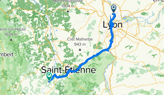
L7 Abkürzung: Fontaines-Saint-Martin - Aurec-sur-Loire; 45+12km mit Bahn Givors-Firminy
A cycling route starting in Fontaines-sur-Saône, Auvergne-Rhône-Alpes, France.
Overview
About this route
Fontaines-Saint-Martin - Lyon - (VR Via Rhona) - Pierre-Benite - Vernaison - Chateau de la Porte - Quartier Du Pont - Givors - Gare de Givors-Ville (45km) - Saint-Romain-en-Gier - La-Flechette - Rive-de-Gier - Izieux - Saint-Etienne Chateaucreux (Gare 28km bis Aurec-sur-Loire) - La Ricamarie - (V72) - Le Chambon-Feugerolles - Firminy (Gare - 12km bis Aurec-sur-Loire) - Saint-Paul-en-Cornillon - La Roche Bernard - Aurec-sur-Loire
- -:--
- Duration
- 112.5 km
- Distance
- 1,355 m
- Ascent
- 1,099 m
- Descent
- ---
- Avg. speed
- 624 m
- Max. altitude

Route quality
Waytypes & surfaces along the route
Waytypes
Quiet road
38.2 km
(34 %)
Cycleway
11.2 km
(10 %)
Surfaces
Paved
72 km
(64 %)
Unpaved
4.5 km
(4 %)
Asphalt
68.6 km
(61 %)
Concrete
3.4 km
(3 %)
Route highlights
Points of interest along the route
Point of interest after 0.3 km
Château de Rochetaillée-sur-Saône
Point of interest after 3.7 km
Paul Bocuse Restaurant - Collonges-au-Mont-d'Or
Point of interest after 13 km
Notre-Dame de Fourvière
Point of interest after 13.7 km
Théâtre Gallo Romain de Lyon-Fourvière
Point of interest after 14.7 km
Fontaine Saint Jean
Point of interest after 15.1 km
Kathedrale von Lyon
Point of interest after 15.5 km
Kirche Saint-Georges
Point of interest after 16.3 km
Place Bellecour
Point of interest after 17.1 km
Statue of the Republic
Point of interest after 18 km
André Marie Ampère monument
Point of interest after 18.5 km
Le Monolithe
Point of interest after 20.3 km
Jardin du Musée des Confluences
Point of interest after 20.5 km
Zusammenfluß Rhone-Saone Confluent du Rhône et de la Saône
Point of interest after 21.6 km
Mulatiere’s Bridge
Point of interest after 24.4 km
Église Notre-Dame de Pierre Bénite
Point of interest after 38.3 km
Museum and site of Saint-Romain-en-Gal Vienne
Point of interest after 40.9 km
Hängebrücke in Givors
Accommodation after 41 km
Hotel Restaurant Le Bellevue, 1 Pl. du Carcan, 38370 Les Roches-de-Condrieu, Frankreich
Point of interest after 42.3 km
Givors Ville - La Gare 45km ab Fontaines-Saint-Martin
Point of interest after 85.5 km
St.Etinne Chateaucreux 27km bis Aurec-sur-Loire
Point of interest after 100.2 km
Firminy - La Gare 12 km nach Aurec-sur-Loire
Continue with Bikemap
Use, edit, or download this cycling route
You would like to ride L7 Abkürzung: Fontaines-Saint-Martin - Aurec-sur-Loire; 45+12km mit Bahn Givors-Firminy or customize it for your own trip? Here is what you can do with this Bikemap route:
Free features
- Save this route as favorite or in collections
- Copy & plan your own version of this route
- Split it into stages to create a multi-day tour
- Sync your route with Garmin or Wahoo
Premium features
Free trial for 3 days, or one-time payment. More about Bikemap Premium.
- Navigate this route on iOS & Android
- Export a GPX / KML file of this route
- Create your custom printout (try it for free)
- Download this route for offline navigation
Discover more Premium features.
Get Bikemap PremiumFrom our community
Other popular routes starting in Fontaines-sur-Saône
 Quai de la Libération, Collonges-au-Mont-d'Or to 5 Chemin de la Chaîne, Ternay
- Distance
- 30.1 km
- Ascent
- 243 m
- Descent
- 243 m
- Location
- Fontaines-sur-Saône, Auvergne-Rhône-Alpes, France
 Fontaine-sur-Saône - Mâcon
- Distance
- 68.3 km
- Ascent
- 47 m
- Descent
- 42 m
- Location
- Fontaines-sur-Saône, Auvergne-Rhône-Alpes, France
 L7 Abkürzung: Fontaines-Saint-Martin - Aurec-sur-Loire; 45+12km mit Bahn Givors-Firminy
- Distance
- 112.5 km
- Ascent
- 1,355 m
- Descent
- 1,099 m
- Location
- Fontaines-sur-Saône, Auvergne-Rhône-Alpes, France
 Big VTT man
- Distance
- 144.7 km
- Ascent
- 3,774 m
- Descent
- 3,779 m
- Location
- Fontaines-sur-Saône, Auvergne-Rhône-Alpes, France
 L7: Fontaines-Saint-Martin - Roches-de-Condrieu; 67,1km 270hm
- Distance
- 67.1 km
- Ascent
- 432 m
- Descent
- 467 m
- Location
- Fontaines-sur-Saône, Auvergne-Rhône-Alpes, France
 Émeline
- Distance
- 41.3 km
- Ascent
- 279 m
- Descent
- 241 m
- Location
- Fontaines-sur-Saône, Auvergne-Rhône-Alpes, France
 Margot route
- Distance
- 54.6 km
- Ascent
- 286 m
- Descent
- 285 m
- Location
- Fontaines-sur-Saône, Auvergne-Rhône-Alpes, France
 c1 Le circuit de Béa
- Distance
- 19.5 km
- Ascent
- 186 m
- Descent
- 183 m
- Location
- Fontaines-sur-Saône, Auvergne-Rhône-Alpes, France
Open it in the app