
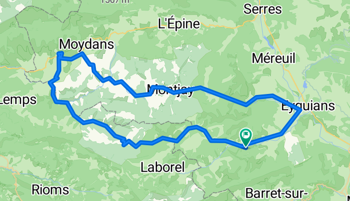
Orpierre Rosans Orpierre
A cycling route starting in Laragne-Montéglin, Provence-Alpes-Côte d'Azur Region, France.
Overview
About this route
- 5 h 5 min
- Duration
- 68.5 km
- Distance
- 1,828 m
- Ascent
- 1,828 m
- Descent
- 13.5 km/h
- Avg. speed
- 1,079 m
- Max. altitude

Route quality
Waytypes & surfaces along the route
Waytypes
Road
64.4 km
(94 %)
Quiet road
2.1 km
(3 %)
Surfaces
Paved
14.4 km
(21 %)
Asphalt
9.6 km
(14 %)
Paved (undefined)
4.8 km
(7 %)
Undefined
54.1 km
(79 %)
Continue with Bikemap
Use, edit, or download this cycling route
You would like to ride Orpierre Rosans Orpierre or customize it for your own trip? Here is what you can do with this Bikemap route:
Free features
- Save this route as favorite or in collections
- Copy & plan your own version of this route
- Sync your route with Garmin or Wahoo
Premium features
Free trial for 3 days, or one-time payment. More about Bikemap Premium.
- Navigate this route on iOS & Android
- Export a GPX / KML file of this route
- Create your custom printout (try it for free)
- Download this route for offline navigation
Discover more Premium features.
Get Bikemap PremiumFrom our community
Other popular routes starting in Laragne-Montéglin
 22-08
22-08- Distance
- 90.6 km
- Ascent
- 1,609 m
- Descent
- 1,149 m
- Location
- Laragne-Montéglin, Provence-Alpes-Côte d'Azur Region, France
 hhhjujjjk
- Distance
- 0.2 km
- Ascent
- 0 m
- Descent
- 0 m
- Location
- Laragne-Montéglin, Provence-Alpes-Côte d'Azur Region, France
 Appeler
- Distance
- 60.2 km
- Ascent
- 1,684 m
- Descent
- 1,654 m
- Location
- Laragne-Montéglin, Provence-Alpes-Côte d'Azur Region, France
 Route nach Serre-des-Ormes, Salérans
- Distance
- 21.9 km
- Ascent
- 852 m
- Descent
- 833 m
- Location
- Laragne-Montéglin, Provence-Alpes-Côte d'Azur Region, France
 5. Etappe FR2018
- Distance
- 92.5 km
- Ascent
- 2,024 m
- Descent
- 2,475 m
- Location
- Laragne-Montéglin, Provence-Alpes-Côte d'Azur Region, France
 D1-Orpierre-St Andre-de-Rosans
- Distance
- 34.1 km
- Ascent
- 622 m
- Descent
- 578 m
- Location
- Laragne-Montéglin, Provence-Alpes-Côte d'Azur Region, France
 ETAPE 5
- Distance
- 67.3 km
- Ascent
- 797 m
- Descent
- 496 m
- Location
- Laragne-Montéglin, Provence-Alpes-Côte d'Azur Region, France
 105 Route du Buëch, Val Buëch-Méouge à 50 Ruelle de la Chèvre d'Or, Val Buëch-Méouge
- Distance
- 12.4 km
- Ascent
- 254 m
- Descent
- 172 m
- Location
- Laragne-Montéglin, Provence-Alpes-Côte d'Azur Region, France
Open it in the app