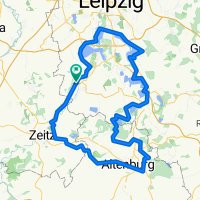
Pegau - Wittenberg (Kohle Dampf Licht Seen)
A cycling route starting in Pegau, Saxony, Germany.
Overview
About this route
- -:--
- Duration
- 185.8 km
- Distance
- 719 m
- Ascent
- 782 m
- Descent
- ---
- Avg. speed
- 155 m
- Avg. speed
Route quality
Waytypes & surfaces along the route
Waytypes
Track
53.8 km
(29 %)
Quiet road
38.3 km
(21 %)
Surfaces
Paved
144.2 km
(78 %)
Unpaved
21.8 km
(12 %)
Asphalt
131.5 km
(71 %)
Gravel
10.3 km
(6 %)
Route highlights
Points of interest along the route
Point of interest after 18.4 km
Aussichtspunkt Tagebau Vereinigtes Schleenhain
Point of interest after 23.2 km
Kraftwerk Lippendorf
Point of interest after 43.4 km
Vineta
Point of interest after 45.8 km
Bergbau Technik Park Großpösna
Point of interest after 61.3 km
Völkerschlachtsdenkmal
Point of interest after 64 km
Buntgarnwerke
Point of interest after 86.6 km
Schaufelrad SRs 6300 Gerbisdorf
Point of interest after 97.7 km
Hotel Zum Weissen Ross
Point of interest after 111.8 km
Bitterfelder Bogen
Point of interest after 117.1 km
Pegelturm an der Goitzsche
Point of interest after 121.2 km
Roter Turm Pouch
Point of interest after 142.5 km
Werkssiedlung und Forum Rathenau
Point of interest after 149.8 km
Ferropolis
Continue with Bikemap
Use, edit, or download this cycling route
You would like to ride Pegau - Wittenberg (Kohle Dampf Licht Seen) or customize it for your own trip? Here is what you can do with this Bikemap route:
Free features
- Save this route as favorite or in collections
- Copy & plan your own version of this route
- Sync your route with Garmin or Wahoo
Premium features
Free trial for 3 days, or one-time payment. More about Bikemap Premium.
- Navigate this route on iOS & Android
- Export a GPX / KML file of this route
- Create your custom printout (try it for free)
- Download this route for offline navigation
Discover more Premium features.
Get Bikemap PremiumFrom our community
Other popular routes starting in Pegau
- Martin-Luther-Platz 14, Pegau nach Leipziger Straße 2, Pegau
- Distance
- 47.8 km
- Ascent
- 229 m
- Descent
- 276 m
- Location
- Pegau, Saxony, Germany
- Kanupark
- Distance
- 17.4 km
- Ascent
- 23 m
- Descent
- 39 m
- Location
- Pegau, Saxony, Germany
- Elsterradweg, Etappe Pegau - Crossen
- Distance
- 56.2 km
- Ascent
- 265 m
- Descent
- 223 m
- Location
- Pegau, Saxony, Germany
- Pegau-drei Seen
- Distance
- 63.7 km
- Ascent
- 163 m
- Descent
- 163 m
- Location
- Pegau, Saxony, Germany
- Pegau - Halle (Saale) (2.Tag)
- Distance
- 66 km
- Ascent
- 54 m
- Descent
- 90 m
- Location
- Pegau, Saxony, Germany
- Störmthal
- Distance
- 19 km
- Ascent
- 35 m
- Descent
- 43 m
- Location
- Pegau, Saxony, Germany
- Floßgraben-Wanderweg Pegau
- Distance
- 9.3 km
- Ascent
- 20 m
- Descent
- 21 m
- Location
- Pegau, Saxony, Germany
- Runde Pegau Monarchenhügel Mondsee Profen
- Distance
- 37.4 km
- Ascent
- 110 m
- Descent
- 112 m
- Location
- Pegau, Saxony, Germany
Open it in the app