

Tentative ride with JEannie
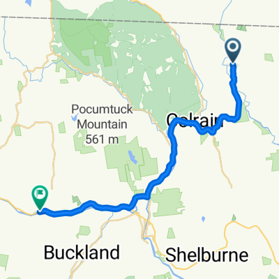
A cycling route starting in Colrain, Massachusetts, United States.
Overview
About this route
- -:--
- Duration
- 67.8 km
- Distance
- 1,170 m
- Ascent
- 666 m
- Descent
- ---
- Avg. speed
- ---
- Max. altitude
Route quality
Waytypes & surfaces along the route
Waytypes
Busy road
38.5 km
(57 %)
Quiet road
17.8 km
(26 %)
Surfaces
Paved
49.8 km
(73 %)
Unpaved
10.9 km
(16 %)
Asphalt
49.8 km
(73 %)
Gravel
6.6 km
(10 %)
Continue with Bikemap
Use, edit, or download this cycling route
You would like to ride Tentative ride with JEannie or customize it for your own trip? Here is what you can do with this Bikemap route:
Free features
- Save this route as favorite or in collections
- Copy & plan your own version of this route
- Sync your route with Garmin or Wahoo
Premium features
Free trial for 3 days, or one-time payment. More about Bikemap Premium.
- Navigate this route on iOS & Android
- Export a GPX / KML file of this route
- Create your custom printout (try it for free)
- Download this route for offline navigation
Discover more Premium features.
Get Bikemap PremiumFrom our community
Other popular routes starting in Colrain
 To Dancing Bear Farm
- Distance
- 7.4 km
- Ascent
- 276 m
- Descent
- 116 m
- Location
- Colrain, Massachusetts, United States
 Leyden 16mi
- Distance
- 25.8 km
- Ascent
- 593 m
- Descent
- 592 m
- Location
- Colrain, Massachusetts, United States
 Leyden Route 5
- Distance
- 25.6 km
- Ascent
- 542 m
- Descent
- 543 m
- Location
- Colrain, Massachusetts, United States
 Home to AAC
- Distance
- 23.7 km
- Ascent
- 350 m
- Descent
- 391 m
- Location
- Colrain, Massachusetts, United States
 Tentative ride with JEannie
- Distance
- 67.8 km
- Ascent
- 1,170 m
- Descent
- 666 m
- Location
- Colrain, Massachusetts, United States
 whittingham and back
- Distance
- 67.1 km
- Ascent
- 897 m
- Descent
- 901 m
- Location
- Colrain, Massachusetts, United States
 OUT: GR Ride
- Distance
- 43.8 km
- Ascent
- 579 m
- Descent
- 304 m
- Location
- Colrain, Massachusetts, United States
 Leyden Route 4
- Distance
- 28.6 km
- Ascent
- 580 m
- Descent
- 581 m
- Location
- Colrain, Massachusetts, United States
Open it in the app