
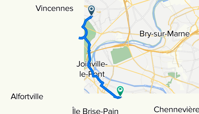
52 Rue du Commandant Jean Duhail, Fontenay-sous-Bois à 14 Place de la Louvière, Saint-Maur-des-Fossés
A cycling route starting in Fontenay-sous-Bois, Île-de-France Region, France.
Overview
About this route
- 18 min
- Duration
- 6.5 km
- Distance
- 28 m
- Ascent
- 49 m
- Descent
- 21.9 km/h
- Avg. speed
- 61 m
- Max. altitude
Route quality
Waytypes & surfaces along the route
Waytypes
Pedestrian area
1.6 km
(25 %)
Road
1.4 km
(22 %)
Surfaces
Paved
5.5 km
(84 %)
Unpaved
0 km
(<1 %)
Asphalt
5.3 km
(82 %)
Paved (undefined)
0.2 km
(3 %)
Continue with Bikemap
Use, edit, or download this cycling route
You would like to ride 52 Rue du Commandant Jean Duhail, Fontenay-sous-Bois à 14 Place de la Louvière, Saint-Maur-des-Fossés or customize it for your own trip? Here is what you can do with this Bikemap route:
Free features
- Save this route as favorite or in collections
- Copy & plan your own version of this route
- Sync your route with Garmin or Wahoo
Premium features
Free trial for 3 days, or one-time payment. More about Bikemap Premium.
- Navigate this route on iOS & Android
- Export a GPX / KML file of this route
- Create your custom printout (try it for free)
- Download this route for offline navigation
Discover more Premium features.
Get Bikemap PremiumFrom our community
Other popular routes starting in Fontenay-sous-Bois
 21 Rue des Mocards, Fontenay-sous-Bois à 1 Rue de la République, Charenton-le-Pont
- Distance
- 6.3 km
- Ascent
- 98 m
- Descent
- 119 m
- Location
- Fontenay-sous-Bois, Île-de-France Region, France
 De 33 Rue Jules Ferry, Fontenay-sous-Bois à 33 Rue Jules Ferry, Fontenay-sous-Bois
- Distance
- 14 km
- Ascent
- 367 m
- Descent
- 367 m
- Location
- Fontenay-sous-Bois, Île-de-France Region, France
 48 Rue du Commandant Jean Duhail, Fontenay-sous-Bois à 9 Quai de Bercy, Charenton-le-Pont
- Distance
- 7.7 km
- Ascent
- 27 m
- Descent
- 53 m
- Location
- Fontenay-sous-Bois, Île-de-France Region, France
 41 Rue du Commandant Jean Duhail, Fontenay-sous-Bois à 102 Avenue Parmentier, Paris
- Distance
- 8.6 km
- Ascent
- 13 m
- Descent
- 34 m
- Location
- Fontenay-sous-Bois, Île-de-France Region, France
 CAP_velo
- Distance
- 147.7 km
- Ascent
- 602 m
- Descent
- 668 m
- Location
- Fontenay-sous-Bois, Île-de-France Region, France
 boucle 65 km Montreuil
- Distance
- 65.2 km
- Ascent
- 393 m
- Descent
- 393 m
- Location
- Fontenay-sous-Bois, Île-de-France Region, France
 travail domicile
- Distance
- 3.3 km
- Ascent
- 55 m
- Descent
- 41 m
- Location
- Fontenay-sous-Bois, Île-de-France Region, France
 Montreuil - Beauchemin 285km
- Distance
- 284.5 km
- Ascent
- 797 m
- Descent
- 497 m
- Location
- Fontenay-sous-Bois, Île-de-France Region, France
Open it in the app