

Woodbine by the Lake 126, Colchester to Woodbine by the Lake 126, Colchester
A cycling route starting in Colchester, Vermont, United States.
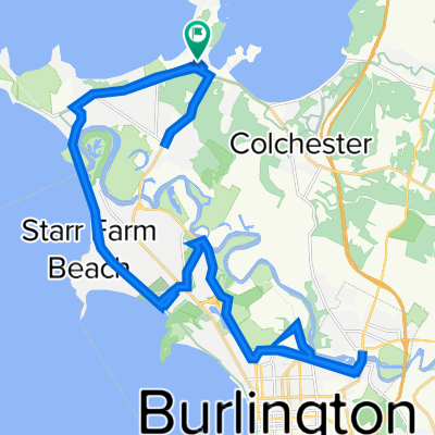
Overview
About this route
- 5 h 12 min
- Duration
- 47 km
- Distance
- 220 m
- Ascent
- 220 m
- Descent
- 9 km/h
- Avg. speed
- 76 m
- Max. altitude

Route quality
Waytypes & surfaces along the route
Waytypes
Cycleway
28.2 km
(60 %)
Quiet road
8 km
(17 %)
Surfaces
Paved
43.2 km
(92 %)
Unpaved
0.9 km
(2 %)
Asphalt
39 km
(83 %)
Paved (undefined)
2.3 km
(5 %)
Continue with Bikemap
Use, edit, or download this cycling route
You would like to ride Woodbine by the Lake 126, Colchester to Woodbine by the Lake 126, Colchester or customize it for your own trip? Here is what you can do with this Bikemap route:
Free features
- Save this route as favorite or in collections
- Copy & plan your own version of this route
- Sync your route with Garmin or Wahoo
Premium features
Free trial for 3 days, or one-time payment. More about Bikemap Premium.
- Navigate this route on iOS & Android
- Export a GPX / KML file of this route
- Create your custom printout (try it for free)
- Download this route for offline navigation
Discover more Premium features.
Get Bikemap PremiumFrom our community
Other popular routes starting in Colchester
 Woodbine by the Lake 126, Colchester to Woodbine by the Lake 126, Colchester
- Distance
- 47 km
- Ascent
- 220 m
- Descent
- 220 m
- Location
- Colchester, Vermont, United States
 Vermont
- Distance
- 421 km
- Ascent
- 2,190 m
- Descent
- 2,193 m
- Location
- Colchester, Vermont, United States
 Colonel Allen Drive to South Street
- Distance
- 28.6 km
- Ascent
- 169 m
- Descent
- 145 m
- Location
- Colchester, Vermont, United States
 Jour 9 - Mallet's Bay@North Hero
- Distance
- 1.9 km
- Ascent
- 83 m
- Descent
- 68 m
- Location
- Colchester, Vermont, United States
 Colonel Allen Drive 28, South Hero to Colonel Allen Drive 28, South Hero
- Distance
- 33.8 km
- Ascent
- 160 m
- Descent
- 153 m
- Location
- Colchester, Vermont, United States
 Rice Memorial High School
- Distance
- 18 km
- Ascent
- 160 m
- Descent
- 114 m
- Location
- Colchester, Vermont, United States
 West Lakeshore Drive 1311, Colchester to Woodbine by the Lake 126, Colchester
- Distance
- 42.9 km
- Ascent
- 226 m
- Descent
- 202 m
- Location
- Colchester, Vermont, United States
 Mad La Tour the Island
- Distance
- 41.5 km
- Ascent
- 210 m
- Descent
- 213 m
- Location
- Colchester, Vermont, United States
Open it in the app