
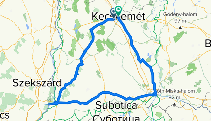
Tour de Alföld
A cycling route starting in Kecskemét, Bács-Kiskun county, Hungary.
Overview
About this route
- 18 h 14 min
- Duration
- 312.8 km
- Distance
- 442 m
- Ascent
- 443 m
- Descent
- 17.2 km/h
- Avg. speed
- 141 m
- Avg. speed

Route quality
Waytypes & surfaces along the route
Waytypes
Cycleway
147.3 km
(47 %)
Busy road
85.6 km
(27 %)
Surfaces
Paved
220.6 km
(71 %)
Unpaved
2.3 km
(<1 %)
Asphalt
212.8 km
(68 %)
Paving stones
7.6 km
(2 %)
Continue with Bikemap
Use, edit, or download this cycling route
You would like to ride Tour de Alföld or customize it for your own trip? Here is what you can do with this Bikemap route:
Free features
- Save this route as favorite or in collections
- Copy & plan your own version of this route
- Split it into stages to create a multi-day tour
- Sync your route with Garmin or Wahoo
Premium features
Free trial for 3 days, or one-time payment. More about Bikemap Premium.
- Navigate this route on iOS & Android
- Export a GPX / KML file of this route
- Create your custom printout (try it for free)
- Download this route for offline navigation
Discover more Premium features.
Get Bikemap PremiumFrom our community
Other popular routes starting in Kecskemét
 Kecskemét 01
- Distance
- 25.5 km
- Ascent
- 30 m
- Descent
- 33 m
- Location
- Kecskemét, Bács-Kiskun county, Hungary
 Kecskemét - Tiszató
- Distance
- 202.5 km
- Ascent
- 38 m
- Descent
- 68 m
- Location
- Kecskemét, Bács-Kiskun county, Hungary
 2020 Dunakanyar oda-vissza
- Distance
- 356 km
- Ascent
- 92 m
- Descent
- 90 m
- Location
- Kecskemét, Bács-Kiskun county, Hungary
 vacsi
vacsi- Distance
- 3.5 km
- Ascent
- 3 m
- Descent
- 0 m
- Location
- Kecskemét, Bács-Kiskun county, Hungary
 Kecskemét edzőkör
- Distance
- 54.5 km
- Ascent
- 32 m
- Descent
- 31 m
- Location
- Kecskemét, Bács-Kiskun county, Hungary
 SZÉP kihívás 2018
- Distance
- 207.1 km
- Ascent
- 86 m
- Descent
- 92 m
- Location
- Kecskemét, Bács-Kiskun county, Hungary
 Kocsér kör
- Distance
- 50.6 km
- Ascent
- 21 m
- Descent
- 23 m
- Location
- Kecskemét, Bács-Kiskun county, Hungary
 TdA 2025 terv
- Distance
- 307.1 km
- Ascent
- 405 m
- Descent
- 403 m
- Location
- Kecskemét, Bács-Kiskun county, Hungary
Open it in the app