

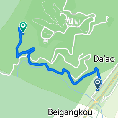
羅運 - 鼎橄社排水閘門
A cycling route starting in Yilan, Taiwan, Taiwan.
Overview
About this route
null
- -:--
- Duration
- 23.5 km
- Distance
- 24 m
- Ascent
- 27 m
- Descent
- ---
- Avg. speed
- 19 m
- Max. altitude

Route quality
Waytypes & surfaces along the route
Waytypes
Cycleway
8 km
(34 %)
Quiet road
6.8 km
(29 %)
Surfaces
Paved
1.4 km
(6 %)
Asphalt
1.4 km
(6 %)
Undefined
22.1 km
(94 %)
Route highlights
Points of interest along the route
Point of interest after 10.8 km
鼎橄社排水閘門
Continue with Bikemap
Use, edit, or download this cycling route
You would like to ride 羅運 - 鼎橄社排水閘門 or customize it for your own trip? Here is what you can do with this Bikemap route:
Free features
- Save this route as favorite or in collections
- Copy & plan your own version of this route
- Sync your route with Garmin or Wahoo
Premium features
Free trial for 3 days, or one-time payment. More about Bikemap Premium.
- Navigate this route on iOS & Android
- Export a GPX / KML file of this route
- Create your custom printout (try it for free)
- Download this route for offline navigation
Discover more Premium features.
Get Bikemap PremiumFrom our community
Other popular routes starting in Yilan
 2011青春卡打車~冬山河→五結大閘門
- Distance
- 25.2 km
- Ascent
- 28 m
- Descent
- 30 m
- Location
- Yilan, Taiwan, Taiwan
 980502_桶后林道
- Distance
- 11.8 km
- Ascent
- 625 m
- Descent
- 418 m
- Location
- Yilan, Taiwan, Taiwan
 Luodong to Keelong
- Distance
- 105.1 km
- Ascent
- 326 m
- Descent
- 324 m
- Location
- Yilan, Taiwan, Taiwan
 金車外澳館到城堡館
- Distance
- 1.8 km
- Ascent
- 279 m
- Descent
- 67 m
- Location
- Yilan, Taiwan, Taiwan
 北進武嶺 (至埔里轉運站)
- Distance
- 203.5 km
- Ascent
- 3,755 m
- Descent
- 3,316 m
- Location
- Yilan, Taiwan, Taiwan
 輕鬆的路線 羅東鎮
- Distance
- 56.8 km
- Ascent
- 379 m
- Descent
- 383 m
- Location
- Yilan, Taiwan, Taiwan
 day01
day01- Distance
- 97.6 km
- Ascent
- 592 m
- Descent
- 550 m
- Location
- Yilan, Taiwan, Taiwan
 太平山
太平山- Distance
- 35.5 km
- Ascent
- 2,002 m
- Descent
- 247 m
- Location
- Yilan, Taiwan, Taiwan
Open it in the app