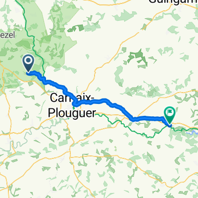
5–27 Place Aristide Briand, Huelgoat nach 1 Rue de Kergus, Plestin-les-Grèves
- 42 km
- 477 m
- 610 m
- Huelgoat, Brittany Region, France
A cycling route starting in Huelgoat, Brittany Region, France.
Overview
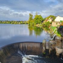
Start: Parking next to the soccer field // Direction of travel clockwise towards Nesvastel Maison du Lac This loop is one of the easiest at the Base of Monts d'Arrée. Following the same start as the Roch Cléguer circuit up to the Nestavel dam, this loop then runs alongside Lake Saint Michel to the north up to the Venec Nature Reserve. This spot is worth a visit and some photos. After that, you will pick up the GR380, before passing by the Ecomusée du Youdig in Kervéguénet. You will reach Brennilis via Kerroland and the Maison de la Réserve Naturelle, before finishing on small paths in the village of Brennilis. A family route without major difficulties, but with beautiful views of the lake and the peat bogs. Type of route: path: 27% track: 27% road: 46% The terrain marking takes precedence over paper guidebooks.
created this 3 years ago
Route quality
Quiet road
5.3 km
45 %
Track
3.5 km
30 %
Paved
3.3 km
(28 %)
Unpaved
3.2 km
(27 %)
Asphalt
3.3 km
28 %
Gravel
2.4 km
20 %
Continue with Bikemap
You would like to ride Brennilis : circuit VTT de Brennilis or customize it for your own trip? Here is what you can do with this Bikemap route:
Free trial for 3 days, or one-time payment. More about Bikemap Premium.
Discover more Premium features.
Get Bikemap PremiumFrom our community
Open it in the app