
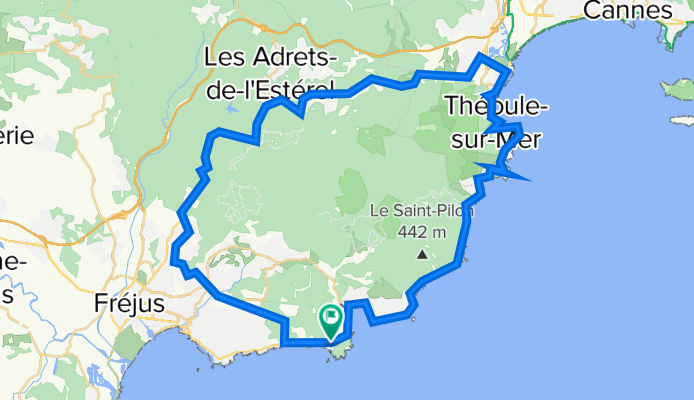
Rundtour Agay
A cycling route starting in Saint-Raphaël, Provence-Alpes-Côte d'Azur Region, France.
Overview
About this route
- -:--
- Duration
- 61.7 km
- Distance
- 946 m
- Ascent
- 948 m
- Descent
- ---
- Avg. speed
- 330 m
- Avg. speed

Route quality
Waytypes & surfaces along the route
Waytypes
Busy road
44.9 km
(73 %)
Quiet road
9 km
(15 %)
Surfaces
Paved
34.5 km
(56 %)
Asphalt
34.5 km
(56 %)
Undefined
27.2 km
(44 %)
Continue with Bikemap
Use, edit, or download this cycling route
You would like to ride Rundtour Agay or customize it for your own trip? Here is what you can do with this Bikemap route:
Free features
- Save this route as favorite or in collections
- Copy & plan your own version of this route
- Sync your route with Garmin or Wahoo
Premium features
Free trial for 3 days, or one-time payment. More about Bikemap Premium.
- Navigate this route on iOS & Android
- Export a GPX / KML file of this route
- Create your custom printout (try it for free)
- Download this route for offline navigation
Discover more Premium features.
Get Bikemap PremiumFrom our community
Other popular routes starting in Saint-Raphaël
 De Avenue de la Grande Corniche 655, Saint-Raphaël à Avenue de l'Armitelle 604 Ter, Saint-Raphaël
- Distance
- 13.9 km
- Ascent
- 34 m
- Descent
- 51 m
- Location
- Saint-Raphaël, Provence-Alpes-Côte d'Azur Region, France
 Esterel2
- Distance
- 35.8 km
- Ascent
- 550 m
- Descent
- 550 m
- Location
- Saint-Raphaël, Provence-Alpes-Côte d'Azur Region, France
 taka góra we Francji
- Distance
- 2.8 km
- Ascent
- 115 m
- Descent
- 113 m
- Location
- Saint-Raphaël, Provence-Alpes-Côte d'Azur Region, France
 les caous
- Distance
- 16.1 km
- Ascent
- 479 m
- Descent
- 491 m
- Location
- Saint-Raphaël, Provence-Alpes-Côte d'Azur Region, France
 Von Boulouris über Tanneron über die Corniche zurück
- Distance
- 84.8 km
- Ascent
- 2,479 m
- Descent
- 2,466 m
- Location
- Saint-Raphaël, Provence-Alpes-Côte d'Azur Region, France
 Esterelleküste und -berge
- Distance
- 64 km
- Ascent
- 584 m
- Descent
- 590 m
- Location
- Saint-Raphaël, Provence-Alpes-Côte d'Azur Region, France
 Boulouris - Cote de maures - zurück über Roquebrune
- Distance
- 109.2 km
- Ascent
- 622 m
- Descent
- 619 m
- Location
- Saint-Raphaël, Provence-Alpes-Côte d'Azur Region, France
 DE LA MER AUX PREMIERS CONTREFORTS…
- Distance
- 69.1 km
- Ascent
- 486 m
- Descent
- 486 m
- Location
- Saint-Raphaël, Provence-Alpes-Côte d'Azur Region, France
Open it in the app