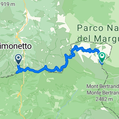
Alta Via del Sale
A cycling route starting in Tende, Provence-Alpes-C么te d'Azur Region, France.
Overview
About this route
1-2 Ottobre 2020
- -:--
- Duration
- 88.1 km
- Distance
- 6,433 m
- Ascent
- 6,464 m
- Descent
- ---
- Avg. speed
- 2,263 m
- Avg. speed
Route quality
Waytypes & surfaces along the route
Waytypes
Track
62.3 km
(71 %)
Path
12.4 km
(14 %)
Surfaces
Paved
6.1 km
(7 %)
Unpaved
64.5 km
(73 %)
Gravel
53.6 km
(61 %)
Ground
9.4 km
(11 %)
Continue with Bikemap
Use, edit, or download this cycling route
You would like to ride Alta Via del Sale or customize it for your own trip? Here is what you can do with this Bikemap route:
Free features
- Save this route as favorite or in collections
- Copy & plan your own version of this route
- Sync your route with Garmin or Wahoo
Premium features
Free trial for 3 days, or one-time payment. More about Bikemap Premium.
- Navigate this route on iOS & Android
- Export a GPX / KML file of this route
- Create your custom printout (try it for free)
- Download this route for offline navigation
Discover more Premium features.
Get Bikemap PremiumFrom our community
Other popular routes starting in Tende
- ALTA VIA DEL SALE - Ciclovia del Mediterraneo (2)
- Distance
- 99.9 km
- Ascent
- 3,592 m
- Descent
- 3,479 m
- Location
- Tende, Provence-Alpes-C么te d'Azur Region, France
- Anello del Colle di Tenda verso Casterino
- Distance
- 47.5 km
- Ascent
- 1,468 m
- Descent
- 1,468 m
- Location
- Tende, Provence-Alpes-C么te d'Azur Region, France
- Tenda -Peirafica - forte_Tabourde - Tenda
- Distance
- 36.3 km
- Ascent
- 1,571 m
- Descent
- 1,589 m
- Location
- Tende, Provence-Alpes-C么te d'Azur Region, France
- 茅t茅 2019
- Distance
- 1,057.7 km
- Ascent
- 12,457 m
- Descent
- 12,458 m
- Location
- Tende, Provence-Alpes-C么te d'Azur Region, France
- Tende-Eze-Valbonne-Port Grimaud-Cannes 2017
- Distance
- 317.7 km
- Ascent
- 1,757 m
- Descent
- 2,577 m
- Location
- Tende, Provence-Alpes-C么te d'Azur Region, France
- AlpesMaritimes15/3.Etappe: St.Dalmas-de-Tende - Tende - Col de Tende/Colle di Tenda - Limone Piemonte - Tenda-Tunnel - St.Dalmas-de-Tende
- Distance
- 50.4 km
- Ascent
- 1,836 m
- Descent
- 1,817 m
- Location
- Tende, Provence-Alpes-C么te d'Azur Region, France
- St.Dalmas-Tenda-Bassa dell'Urna-Colle di Tenda-St.Dalmas
- Distance
- 50.7 km
- Ascent
- 1,489 m
- Descent
- 1,516 m
- Location
- Tende, Provence-Alpes-C么te d'Azur Region, France
- Vievola-Colle di Tenda-Bassa di Peirafica-Castorino-St.Dalmas
- Distance
- 40.3 km
- Ascent
- 1,174 m
- Descent
- 1,444 m
- Location
- Tende, Provence-Alpes-C么te d'Azur Region, France
Open it in the app