

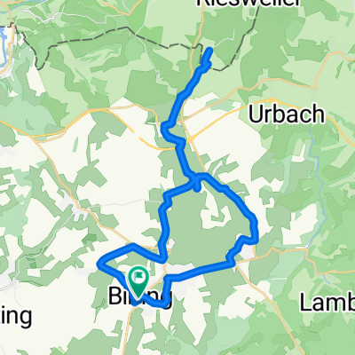
Bining-Rahling
A cycling route starting in Bining, Grand Est, France.
Overview
About this route
The route mostly runs along little-trafficked rural roads. The first and last segment is along paved forest or agricultural paths. Depending on the direction of travel ;-)
- -:--
- Duration
- 20.8 km
- Distance
- 294 m
- Ascent
- 294 m
- Descent
- ---
- Avg. speed
- ---
- Max. altitude
Continue with Bikemap
Use, edit, or download this cycling route
You would like to ride Bining-Rahling or customize it for your own trip? Here is what you can do with this Bikemap route:
Free features
- Save this route as favorite or in collections
- Copy & plan your own version of this route
- Sync your route with Garmin or Wahoo
Premium features
Free trial for 3 days, or one-time payment. More about Bikemap Premium.
- Navigate this route on iOS & Android
- Export a GPX / KML file of this route
- Create your custom printout (try it for free)
- Download this route for offline navigation
Discover more Premium features.
Get Bikemap PremiumFrom our community
Other popular routes starting in Bining
 Bining-Rahling
- Distance
- 20.8 km
- Ascent
- 294 m
- Descent
- 294 m
- Location
- Bining, Grand Est, France
 De Äå?‰? à Äå?‰?
- Distance
- 17.6 km
- Ascent
- 80 m
- Descent
- 160 m
- Location
- Bining, Grand Est, France
 Rue d'Alsace, Rahling à Kalhausen
- Distance
- 91.9 km
- Ascent
- 1,417 m
- Descent
- 1,447 m
- Location
- Bining, Grand Est, France
 Peppenkum 1er Versuch
- Distance
- 32.6 km
- Ascent
- 231 m
- Descent
- 248 m
- Location
- Bining, Grand Est, France
 Tour-180709
- Distance
- 17.9 km
- Ascent
- 267 m
- Descent
- 302 m
- Location
- Bining, Grand Est, France
 Bininger Wald 1
- Distance
- 11.3 km
- Ascent
- 159 m
- Descent
- 116 m
- Location
- Bining, Grand Est, France
 Tour240709
- Distance
- 24 km
- Ascent
- 324 m
- Descent
- 324 m
- Location
- Bining, Grand Est, France
 Itinéraire reposant en Butten
- Distance
- 8.9 km
- Ascent
- 200 m
- Descent
- 285 m
- Location
- Bining, Grand Est, France
Open it in the app