

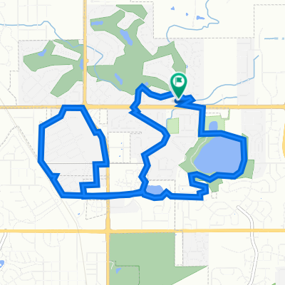
V 2 Lafayette to NCAR via Manhattan
A cycling route starting in Lafayette, Colorado, United States.
Overview
About this route
- -:--
- Duration
- 20.8 km
- Distance
- 380 m
- Ascent
- 140 m
- Descent
- ---
- Avg. speed
- 1,869 m
- Max. altitude

Route quality
Waytypes & surfaces along the route
Waytypes
Quiet road
7.9 km
(38 %)
Cycleway
3.7 km
(18 %)
Surfaces
Paved
15.2 km
(73 %)
Unpaved
0.4 km
(2 %)
Concrete
8.1 km
(39 %)
Asphalt
6.9 km
(33 %)
Continue with Bikemap
Use, edit, or download this cycling route
You would like to ride V 2 Lafayette to NCAR via Manhattan or customize it for your own trip? Here is what you can do with this Bikemap route:
Free features
- Save this route as favorite or in collections
- Copy & plan your own version of this route
- Sync your route with Garmin or Wahoo
Premium features
Free trial for 3 days, or one-time payment. More about Bikemap Premium.
- Navigate this route on iOS & Android
- Export a GPX / KML file of this route
- Create your custom printout (try it for free)
- Download this route for offline navigation
Discover more Premium features.
Get Bikemap PremiumFrom our community
Other popular routes starting in Lafayette
 Home to Interlocken Blvd. through HWY 36 tunnel
- Distance
- 24.6 km
- Ascent
- 1,487 m
- Descent
- 1,486 m
- Location
- Lafayette, Colorado, United States
 317 Sleeping Owl Pt, Lafayette to 317 Sleeping Owl Pt, Lafayette
- Distance
- 15.6 km
- Ascent
- 139 m
- Descent
- 139 m
- Location
- Lafayette, Colorado, United States
 317 Sleeping Owl Pt, Lafayette to 317 Sleeping Owl Pt, Lafayette
- Distance
- 25.2 km
- Ascent
- 165 m
- Descent
- 170 m
- Location
- Lafayette, Colorado, United States
 Ride to work
- Distance
- 10.6 km
- Ascent
- 89 m
- Descent
- 17 m
- Location
- Lafayette, Colorado, United States
 V 2 Lafayette to NCAR via Manhattan
- Distance
- 20.8 km
- Ascent
- 380 m
- Descent
- 140 m
- Location
- Lafayette, Colorado, United States
 317 Sleeping Owl Pt, Lafayette to 317 Sleeping Owl Pt, Lafayette
- Distance
- 10.8 km
- Ascent
- 68 m
- Descent
- 67 m
- Location
- Lafayette, Colorado, United States
 Aspen Lodge Way 16154, Broomfield to Aspen Lodge Way 16154, Broomfield
- Distance
- 35 km
- Ascent
- 212 m
- Descent
- 199 m
- Location
- Lafayette, Colorado, United States
 Superior Table Mesa Loop
- Distance
- 43 km
- Ascent
- 427 m
- Descent
- 424 m
- Location
- Lafayette, Colorado, United States
Open it in the app