

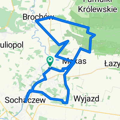
Sochaczew-Warszawa
A cycling route starting in Sochaczew, Masovian Voivodeship, Poland.
Overview
About this route
A very interesting route from Sochaczew through Brochów to the Kampinos Forest and through the forest to Warsaw. Many historical sites, challenging climbs, interesting descents... However, there are few people, especially in the western part. A lap through the city is 'winding up to 100 km ;) The map does not account for the access to PKP and slight wandering. By necessity, it is approximate.
- -:--
- Duration
- 85.3 km
- Distance
- 132 m
- Ascent
- 114 m
- Descent
- ---
- Avg. speed
- ---
- Max. altitude
Route quality
Waytypes & surfaces along the route
Waytypes
Track
26.4 km
(31 %)
Quiet road
17.1 km
(20 %)
Surfaces
Paved
28.1 km
(33 %)
Unpaved
31.6 km
(37 %)
Asphalt
28.1 km
(33 %)
Ground
23.9 km
(28 %)
Continue with Bikemap
Use, edit, or download this cycling route
You would like to ride Sochaczew-Warszawa or customize it for your own trip? Here is what you can do with this Bikemap route:
Free features
- Save this route as favorite or in collections
- Copy & plan your own version of this route
- Split it into stages to create a multi-day tour
- Sync your route with Garmin or Wahoo
Premium features
Free trial for 3 days, or one-time payment. More about Bikemap Premium.
- Navigate this route on iOS & Android
- Export a GPX / KML file of this route
- Create your custom printout (try it for free)
- Download this route for offline navigation
Discover more Premium features.
Get Bikemap PremiumFrom our community
Other popular routes starting in Sochaczew
 Tour de Olympiastadion Berlin 2015 - dzień 1
- Distance
- 195 km
- Ascent
- 164 m
- Descent
- 151 m
- Location
- Sochaczew, Masovian Voivodeship, Poland
 Śladami Chopina okolice Sochaczewa
- Distance
- 45.4 km
- Ascent
- 69 m
- Descent
- 70 m
- Location
- Sochaczew, Masovian Voivodeship, Poland
 Marii Konopnickiej 32B, Sochaczew do Marii Konopnickiej 32B, Sochaczew
- Distance
- 36.8 km
- Ascent
- 125 m
- Descent
- 155 m
- Location
- Sochaczew, Masovian Voivodeship, Poland
 Sochaczew-Warszawa
- Distance
- 85.3 km
- Ascent
- 132 m
- Descent
- 114 m
- Location
- Sochaczew, Masovian Voivodeship, Poland
 Leśna
Leśna- Distance
- 15.6 km
- Ascent
- 36 m
- Descent
- 34 m
- Location
- Sochaczew, Masovian Voivodeship, Poland
 Stefana Okrzei 23, Sochaczew do guzowska 4, Teresin
- Distance
- 17.6 km
- Ascent
- 20 m
- Descent
- 55 m
- Location
- Sochaczew, Masovian Voivodeship, Poland
 Sochaczew - Piastów przez Leoncin
- Distance
- 83.8 km
- Ascent
- 91 m
- Descent
- 81 m
- Location
- Sochaczew, Masovian Voivodeship, Poland
 Stefana Okrzei 22A, Sochaczew do guzowska 4, Teresin
- Distance
- 17.6 km
- Ascent
- 24 m
- Descent
- 57 m
- Location
- Sochaczew, Masovian Voivodeship, Poland
Open it in the app