

札幌市立大ライド
A cycling route starting in Sapporo, Hokkaido, Japan.
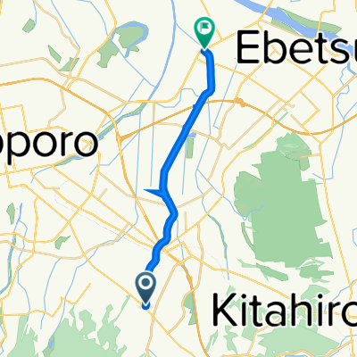
Overview
About this route
- -:--
- Duration
- 37.1 km
- Distance
- 413 m
- Ascent
- 416 m
- Descent
- ---
- Avg. speed
- 259 m
- Max. altitude

Continue with Bikemap
Use, edit, or download this cycling route
You would like to ride 札幌市立大ライド or customize it for your own trip? Here is what you can do with this Bikemap route:
Free features
- Save this route as favorite or in collections
- Copy & plan your own version of this route
- Sync your route with Garmin or Wahoo
Premium features
Free trial for 3 days, or one-time payment. More about Bikemap Premium.
- Navigate this route on iOS & Android
- Export a GPX / KML file of this route
- Create your custom printout (try it for free)
- Download this route for offline navigation
Discover more Premium features.
Get Bikemap PremiumFrom our community
Other popular routes starting in Sapporo
 toyohira towards the sea
- Distance
- 29.7 km
- Ascent
- 43 m
- Descent
- 57 m
- Location
- Sapporo, Hokkaido, Japan
 Sapporo around the island
- Distance
- 1,561.5 km
- Ascent
- 11,216 m
- Descent
- 11,216 m
- Location
- Sapporo, Hokkaido, Japan
 ripple
- Distance
- 86.7 km
- Ascent
- 240 m
- Descent
- 246 m
- Location
- Sapporo, Hokkaido, Japan
 Alt. route Sapporo - Lake Shikotsu
- Distance
- 51.3 km
- Ascent
- 861 m
- Descent
- 632 m
- Location
- Sapporo, Hokkaido, Japan
 札幌市立大ライド
- Distance
- 37.1 km
- Ascent
- 413 m
- Descent
- 416 m
- Location
- Sapporo, Hokkaido, Japan
 Around Hokkaido 1
- Distance
- 1,327.2 km
- Ascent
- 2,592 m
- Descent
- 2,619 m
- Location
- Sapporo, Hokkaido, Japan
 7丁目 2, 札幌市 まで7丁目 2, 札幌市
- Distance
- 20.8 km
- Ascent
- 92 m
- Descent
- 124 m
- Location
- Sapporo, Hokkaido, Japan
 atsubetsu river
- Distance
- 14.5 km
- Ascent
- 0 m
- Descent
- 33 m
- Location
- Sapporo, Hokkaido, Japan
Open it in the app