

Tonkin Guilford Kwinana Roe
A cycling route starting in City of Cockburn, Western Australia, Australia.
Overview
About this route
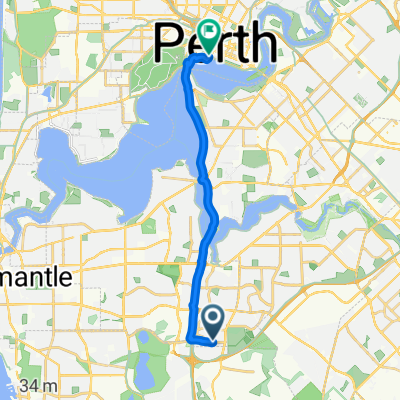
Tonkin Guilford Kwinana Roe
- -:--
- Duration
- 58.5 km
- Distance
- 315 m
- Ascent
- 318 m
- Descent
- ---
- Avg. speed
- 44 m
- Max. altitude

Route quality
Waytypes & surfaces along the route
Waytypes
Cycleway
33.9 km
(58 %)
Path
14.6 km
(25 %)
Surfaces
Paved
52.1 km
(89 %)
Asphalt
36.9 km
(63 %)
Paved (undefined)
12.9 km
(22 %)
Continue with Bikemap
Use, edit, or download this cycling route
You would like to ride Tonkin Guilford Kwinana Roe or customize it for your own trip? Here is what you can do with this Bikemap route:
Free features
- Save this route as favorite or in collections
- Copy & plan your own version of this route
- Sync your route with Garmin or Wahoo
Premium features
Free trial for 3 days, or one-time payment. More about Bikemap Premium.
- Navigate this route on iOS & Android
- Export a GPX / KML file of this route
- Create your custom printout (try it for free)
- Download this route for offline navigation
Discover more Premium features.
Get Bikemap PremiumFrom our community
Other popular routes starting in City of Cockburn
 Barra Cl, Leeming to Duchess Way, Perth
- Distance
- 17.1 km
- Ascent
- 46 m
- Descent
- 72 m
- Location
- City of Cockburn, Western Australia, Australia
 Scarborough run
- Distance
- 71.3 km
- Ascent
- 272 m
- Descent
- 276 m
- Location
- City of Cockburn, Western Australia, Australia
 Tonkin Guilford Kwinana Roe
- Distance
- 58.5 km
- Ascent
- 315 m
- Descent
- 318 m
- Location
- City of Cockburn, Western Australia, Australia
 Lengthy ride through Leeming
- Distance
- 64.1 km
- Ascent
- 174 m
- Descent
- 171 m
- Location
- City of Cockburn, Western Australia, Australia
 perth - broken hill ,rail track and road 1988
- Distance
- 2,747 km
- Ascent
- 1,493 m
- Descent
- 1,215 m
- Location
- City of Cockburn, Western Australia, Australia
 Pilatus Street, Jandakot to Lyon Road 79, Atwell
- Distance
- 32.9 km
- Ascent
- 23 m
- Descent
- 21 m
- Location
- City of Cockburn, Western Australia, Australia
 perth - halls creek 1982, via cannning and wolfe creater
- Distance
- 2,350.7 km
- Ascent
- 1,635 m
- Descent
- 1,259 m
- Location
- City of Cockburn, Western Australia, Australia
 Moondarra Circle 7, South Lake to Pozieres Road 1, Swanbourne
- Distance
- 25.8 km
- Ascent
- 147 m
- Descent
- 100 m
- Location
- City of Cockburn, Western Australia, Australia
Open it in the app