

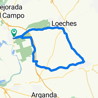
Ruta Carretera 17: 104 Km 1021 m - "Pioz y Nuevo Baztán"
A cycling route starting in Velilla de San Antonio, Madrid, Spain.
Overview
About this route
Rivas-Vaciamadrid - Mejorada del Campo - Torres de la Alameda - Valverde de Alcalá - Corpa - Pezuela de las Torres - Pioz - Ambite - Villar del Olmo - Olmeda de las Fuentes - Nuevo Baztán - Pozo de Guadalajara - Loeches - Velilla de San Antonio - Mejorada del Campo - Rivas-Vaciamadrid - Rivas-Vaciamadrid - Mejorada del Campo - Torres de la Alameda - Valverde de Alcalá - Corpa - Pezuela de las Torres - Pioz - Ambite - Villar del Olmo - Olmeda de las Fuentes - Nuevo Baztán - Pozuelo del Rey - Loeches - Velilla de San Antonio - Mejorada del Campo - Rivas-Vaciamadrid
- -:--
- Duration
- 103.9 km
- Distance
- 845 m
- Ascent
- 848 m
- Descent
- ---
- Avg. speed
- 874 m
- Max. altitude

Route quality
Waytypes & surfaces along the route
Waytypes
Road
59.2 km
(57 %)
Track
9.4 km
(9 %)
Surfaces
Paved
26 km
(25 %)
Unpaved
7.3 km
(7 %)
Asphalt
21.8 km
(21 %)
Ground
6.2 km
(6 %)
Continue with Bikemap
Use, edit, or download this cycling route
You would like to ride Ruta Carretera 17: 104 Km 1021 m - "Pioz y Nuevo Baztán" or customize it for your own trip? Here is what you can do with this Bikemap route:
Free features
- Save this route as favorite or in collections
- Copy & plan your own version of this route
- Split it into stages to create a multi-day tour
- Sync your route with Garmin or Wahoo
Premium features
Free trial for 3 days, or one-time payment. More about Bikemap Premium.
- Navigate this route on iOS & Android
- Export a GPX / KML file of this route
- Create your custom printout (try it for free)
- Download this route for offline navigation
Discover more Premium features.
Get Bikemap PremiumFrom our community
Other popular routes starting in Velilla de San Antonio
 Ruta Carretera 01: 51 Km 298 m - "El Gurugú"
- Distance
- 53 km
- Ascent
- 262 m
- Descent
- 264 m
- Location
- Velilla de San Antonio, Madrid, Spain
 De Calle del Laurel, 46, Rivas-Vaciamadrid a Calle del Laurel, 46, Rivas-Vaciamadrid
- Distance
- 4 km
- Ascent
- 39 m
- Descent
- 37 m
- Location
- Velilla de San Antonio, Madrid, Spain
 Ruta Carretera 44: 70 Km 514 m - "Campo Real"
- Distance
- 70.3 km
- Ascent
- 451 m
- Descent
- 453 m
- Location
- Velilla de San Antonio, Madrid, Spain
 Ruta Carretera 47: 98 Km 898 m - "San Martín, Chinchón y Frascuelo"
- Distance
- 98.1 km
- Ascent
- 541 m
- Descent
- 541 m
- Location
- Velilla de San Antonio, Madrid, Spain
 Velilla - Loeches - Campo Real - Velilla de San Antonio
- Distance
- 24.3 km
- Ascent
- 312 m
- Descent
- 312 m
- Location
- Velilla de San Antonio, Madrid, Spain
 Velilla de san Antonio a sanfernando de Henares
- Distance
- 16.8 km
- Ascent
- 51 m
- Descent
- 44 m
- Location
- Velilla de San Antonio, Madrid, Spain
 Velilla - Rivas
- Distance
- 28.3 km
- Ascent
- 204 m
- Descent
- 205 m
- Location
- Velilla de San Antonio, Madrid, Spain
 Los Cortados
- Distance
- 25.7 km
- Ascent
- 302 m
- Descent
- 299 m
- Location
- Velilla de San Antonio, Madrid, Spain
Open it in the app