

Recovered Route
A cycling route starting in Keidelheim, Rhineland-Palatinate, Germany.
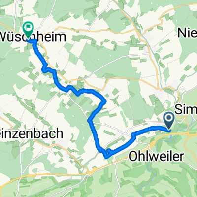
Overview
About this route
- 1 h 3 min
- Duration
- 5.6 km
- Distance
- 1,009 m
- Ascent
- 952 m
- Descent
- 5.3 km/h
- Avg. speed
- 428 m
- Max. altitude
Continue with Bikemap
Use, edit, or download this cycling route
You would like to ride Recovered Route or customize it for your own trip? Here is what you can do with this Bikemap route:
Free features
- Save this route as favorite or in collections
- Copy & plan your own version of this route
- Sync your route with Garmin or Wahoo
Premium features
Free trial for 3 days, or one-time payment. More about Bikemap Premium.
- Navigate this route on iOS & Android
- Export a GPX / KML file of this route
- Create your custom printout (try it for free)
- Download this route for offline navigation
Discover more Premium features.
Get Bikemap PremiumFrom our community
Other popular routes starting in Keidelheim
 E42 nach L226
- Distance
- 12.7 km
- Ascent
- 142 m
- Descent
- 76 m
- Location
- Keidelheim, Rhineland-Palatinate, Germany
 Gartenstraße 11, Kümbdchen nach Rúa do Vilar 49, Santiago de Compostela
- Distance
- 2,238.2 km
- Ascent
- 13,773 m
- Descent
- 13,867 m
- Location
- Keidelheim, Rhineland-Palatinate, Germany
 Gartenstraße 8, Kümbdchen nach Kegelbahn 1, Bell (Hunsrück)
- Distance
- 16.8 km
- Ascent
- 226 m
- Descent
- 108 m
- Location
- Keidelheim, Rhineland-Palatinate, Germany
 Ahornweg 8, Keidelheim nach Auf dem Mohr 1, Reckershausen
- Distance
- 11 km
- Ascent
- 158 m
- Descent
- 85 m
- Location
- Keidelheim, Rhineland-Palatinate, Germany
 aidas
aidas- Distance
- 37.7 km
- Ascent
- 1,056 m
- Descent
- 965 m
- Location
- Keidelheim, Rhineland-Palatinate, Germany
 Ahornweg 8, Keidelheim nach Moselstraße 24, Maring-Noviand
- Distance
- 79.9 km
- Ascent
- 647 m
- Descent
- 878 m
- Location
- Keidelheim, Rhineland-Palatinate, Germany
 Soonwald Tour
- Distance
- 73.4 km
- Ascent
- 1,060 m
- Descent
- 1,057 m
- Location
- Keidelheim, Rhineland-Palatinate, Germany
 Simmern - Bingen
- Distance
- 40.1 km
- Ascent
- 339 m
- Descent
- 598 m
- Location
- Keidelheim, Rhineland-Palatinate, Germany
Open it in the app