

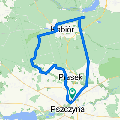
Piastowska 11, Pszczyna do Pszczyna, Pszczyna
A cycling route starting in Pszczyna, Silesian Voivodeship, Poland.
Overview
About this route
- 26 min
- Duration
- 1.4 km
- Distance
- 7 m
- Ascent
- 10 m
- Descent
- 3.2 km/h
- Avg. speed
- 251 m
- Max. altitude

Route quality
Waytypes & surfaces along the route
Waytypes
Path
0.9 km
(66 %)
Living street
0.2 km
(14 %)
Surfaces
Paved
0.3 km
(25 %)
Unpaved
0.1 km
(4 %)
Asphalt
0.3 km
(25 %)
Gravel
0.1 km
(4 %)
Undefined
1 km
(71 %)
Continue with Bikemap
Use, edit, or download this cycling route
You would like to ride Piastowska 11, Pszczyna do Pszczyna, Pszczyna or customize it for your own trip? Here is what you can do with this Bikemap route:
Free features
- Save this route as favorite or in collections
- Copy & plan your own version of this route
- Sync your route with Garmin or Wahoo
Premium features
Free trial for 3 days, or one-time payment. More about Bikemap Premium.
- Navigate this route on iOS & Android
- Export a GPX / KML file of this route
- Create your custom printout (try it for free)
- Download this route for offline navigation
Discover more Premium features.
Get Bikemap PremiumFrom our community
Other popular routes starting in Pszczyna
 Trasa widokowa Goczałkowice
- Distance
- 22.3 km
- Ascent
- 1,199 m
- Descent
- 1,223 m
- Location
- Pszczyna, Silesian Voivodeship, Poland
 Pszczyna-Skoczów
- Distance
- 28.3 km
- Ascent
- 134 m
- Descent
- 88 m
- Location
- Pszczyna, Silesian Voivodeship, Poland
 Lasy kobiórske
- Distance
- 53.4 km
- Ascent
- 184 m
- Descent
- 229 m
- Location
- Pszczyna, Silesian Voivodeship, Poland
 Strażacka to Zacisze
- Distance
- 101.2 km
- Ascent
- 559 m
- Descent
- 538 m
- Location
- Pszczyna, Silesian Voivodeship, Poland
 Pszczyna - dookoła jeziora Goczałkowickiego
- Distance
- 46.3 km
- Ascent
- 96 m
- Descent
- 96 m
- Location
- Pszczyna, Silesian Voivodeship, Poland
 Trasa z Łowiecka, Pszczyna
- Distance
- 18.5 km
- Ascent
- 62 m
- Descent
- 71 m
- Location
- Pszczyna, Silesian Voivodeship, Poland
 Pszczyna - Żar - Żywiec - Pszczyna
- Distance
- 126.1 km
- Ascent
- 651 m
- Descent
- 653 m
- Location
- Pszczyna, Silesian Voivodeship, Poland
 Sucharskiego to Sucharskiego
- Distance
- 32.1 km
- Ascent
- 92 m
- Descent
- 138 m
- Location
- Pszczyna, Silesian Voivodeship, Poland
Open it in the app