

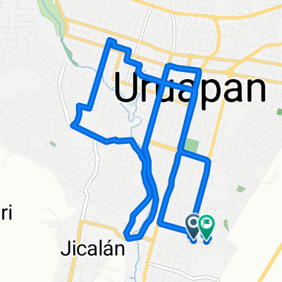
De Miguel Hidalgo 74, Uruapan a Calle Lirio 429, Uruapan
A cycling route starting in Santa Rosa (Santa Bárbara), Michoacán, Mexico.
Overview
About this route
- 4 h 34 min
- Duration
- 49 km
- Distance
- 476 m
- Ascent
- 448 m
- Descent
- 10.8 km/h
- Avg. speed
- 1,703 m
- Max. altitude

Continue with Bikemap
Use, edit, or download this cycling route
You would like to ride De Miguel Hidalgo 74, Uruapan a Calle Lirio 429, Uruapan or customize it for your own trip? Here is what you can do with this Bikemap route:
Free features
- Save this route as favorite or in collections
- Copy & plan your own version of this route
- Sync your route with Garmin or Wahoo
Premium features
Free trial for 3 days, or one-time payment. More about Bikemap Premium.
- Navigate this route on iOS & Android
- Export a GPX / KML file of this route
- Create your custom printout (try it for free)
- Download this route for offline navigation
Discover more Premium features.
Get Bikemap PremiumFrom our community
Other popular routes starting in Santa Rosa (Santa Bárbara)
 uruapan ruinas volcanicas
- Distance
- 50.2 km
- Ascent
- 1,009 m
- Descent
- 339 m
- Location
- Santa Rosa (Santa Bárbara), Michoacán, Mexico
 De Miguel Hidalgo 74, Uruapan a Calle Lirio 429, Uruapan
- Distance
- 49 km
- Ascent
- 476 m
- Descent
- 448 m
- Location
- Santa Rosa (Santa Bárbara), Michoacán, Mexico
 san juan volcan
- Distance
- 43.8 km
- Ascent
- 1,236 m
- Descent
- 262 m
- Location
- Santa Rosa (Santa Bárbara), Michoacán, Mexico
 ruta 5
- Distance
- 16.9 km
- Ascent
- 269 m
- Descent
- 245 m
- Location
- Santa Rosa (Santa Bárbara), Michoacán, Mexico
 uruapan - volcan paricutin
- Distance
- 35.2 km
- Ascent
- 1,012 m
- Descent
- 332 m
- Location
- Santa Rosa (Santa Bárbara), Michoacán, Mexico
 apatzingan
- Distance
- 86.8 km
- Ascent
- 168 m
- Descent
- 1,437 m
- Location
- Santa Rosa (Santa Bárbara), Michoacán, Mexico
 uruapan ruinas volcanicas
- Distance
- 42.4 km
- Ascent
- 1,026 m
- Descent
- 357 m
- Location
- Santa Rosa (Santa Bárbara), Michoacán, Mexico
 enpedrado
- Distance
- 42.6 km
- Ascent
- 522 m
- Descent
- 524 m
- Location
- Santa Rosa (Santa Bárbara), Michoacán, Mexico
Open it in the app