

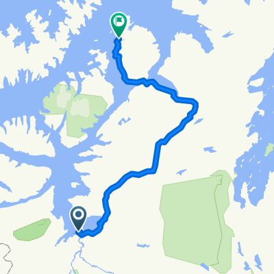
Kautokeinoveien, Alta to Killiveien 95, Alta
A cycling route starting in Alta, Finnmark, Norway.
Overview
About this route
- 1 h 3 min
- Duration
- 4.5 km
- Distance
- 138 m
- Ascent
- 129 m
- Descent
- 4.3 km/h
- Avg. speed
- 45 m
- Max. altitude

Continue with Bikemap
Use, edit, or download this cycling route
You would like to ride Kautokeinoveien, Alta to Killiveien 95, Alta or customize it for your own trip? Here is what you can do with this Bikemap route:
Free features
- Save this route as favorite or in collections
- Copy & plan your own version of this route
- Sync your route with Garmin or Wahoo
Premium features
Free trial for 3 days, or one-time payment. More about Bikemap Premium.
- Navigate this route on iOS & Android
- Export a GPX / KML file of this route
- Create your custom printout (try it for free)
- Download this route for offline navigation
Discover more Premium features.
Get Bikemap PremiumFrom our community
Other popular routes starting in Alta
 2007_11 Trondheim Nordkap
- Distance
- 141.8 km
- Ascent
- 1,512 m
- Descent
- 1,534 m
- Location
- Alta, Finnmark, Norway
 Finnmarksruta
- Distance
- 622.5 km
- Ascent
- 1,154 m
- Descent
- 1,199 m
- Location
- Alta, Finnmark, Norway
 Etappe 40 : Øvre Alta - Skaidi
- Distance
- 96.8 km
- Ascent
- 721 m
- Descent
- 679 m
- Location
- Alta, Finnmark, Norway
 Alta - Burfjord
- Distance
- 100.8 km
- Ascent
- 87 m
- Descent
- 147 m
- Location
- Alta, Finnmark, Norway
 Kautokeinoveien, Alta to Killiveien 95, Alta
- Distance
- 4.5 km
- Ascent
- 138 m
- Descent
- 129 m
- Location
- Alta, Finnmark, Norway
 E31.1 Alta nach Olderfjord
- Distance
- 111.4 km
- Ascent
- 977 m
- Descent
- 1,005 m
- Location
- Alta, Finnmark, Norway
 Raipas øst
- Distance
- 33.4 km
- Ascent
- 556 m
- Descent
- 554 m
- Location
- Alta, Finnmark, Norway
 Alta - Campingplatz
- Distance
- 5.9 km
- Ascent
- 68 m
- Descent
- 46 m
- Location
- Alta, Finnmark, Norway
Open it in the app