

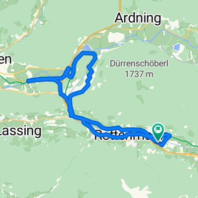
Rottenmann-Mödlinger Hütte
A cycling route starting in Rottenmann, Styria, Austria.
Overview
About this route
- 2 h 46 min
- Duration
- 51.4 km
- Distance
- 1,005 m
- Ascent
- 1,012 m
- Descent
- 18.6 km/h
- Avg. speed
- 1,538 m
- Max. altitude

Continue with Bikemap
Use, edit, or download this cycling route
You would like to ride Rottenmann-Mödlinger Hütte or customize it for your own trip? Here is what you can do with this Bikemap route:
Free features
- Save this route as favorite or in collections
- Copy & plan your own version of this route
- Sync your route with Garmin or Wahoo
Premium features
Free trial for 3 days, or one-time payment. More about Bikemap Premium.
- Navigate this route on iOS & Android
- Export a GPX / KML file of this route
- Create your custom printout (try it for free)
- Download this route for offline navigation
Discover more Premium features.
Get Bikemap PremiumFrom our community
Other popular routes starting in Rottenmann
 Rottenmann-Gaishorner See-Rottenmann
- Distance
- 39.8 km
- Ascent
- 175 m
- Descent
- 221 m
- Location
- Rottenmann, Styria, Austria
 Irdning
- Distance
- 63 km
- Ascent
- 124 m
- Descent
- 121 m
- Location
- Rottenmann, Styria, Austria
 Sankt Georgen 46a, Sankt Georgen nach Sankt Georgen 46a, Sankt Georgen
- Distance
- 30.6 km
- Ascent
- 328 m
- Descent
- 256 m
- Location
- Rottenmann, Styria, Austria
 Strechau, Rottenmann nach Österreichische Romantikstraße, Aigen im Ennstal
- Distance
- 13.2 km
- Ascent
- 135 m
- Descent
- 155 m
- Location
- Rottenmann, Styria, Austria
 Easy ride in Rottenmann
- Distance
- 6.1 km
- Ascent
- 347 m
- Descent
- 28 m
- Location
- Rottenmann, Styria, Austria
 Liezen
- Distance
- 167.5 km
- Ascent
- 2,089 m
- Descent
- 2,341 m
- Location
- Rottenmann, Styria, Austria
 PyhrnpassWengKaiserau
- Distance
- 136.4 km
- Ascent
- 1,418 m
- Descent
- 1,418 m
- Location
- Rottenmann, Styria, Austria
 Leoben Selzthal
- Distance
- 74 km
- Ascent
- 691 m
- Descent
- 793 m
- Location
- Rottenmann, Styria, Austria
Open it in the app