

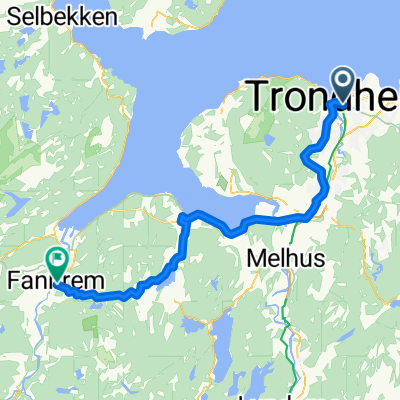
Møllenberg-Byneset-Osloveien-Stavne-Møllenberg
A cycling route starting in Trondheim, Sør-Trøndelag Fylke, Norway.
Overview
About this route
- -:--
- Duration
- 50.3 km
- Distance
- 574 m
- Ascent
- 566 m
- Descent
- ---
- Avg. speed
- ---
- Max. altitude

Route quality
Waytypes & surfaces along the route
Waytypes
Cycleway
9.6 km
(19 %)
Quiet road
3 km
(6 %)
Surfaces
Paved
46.3 km
(92 %)
Unpaved
1 km
(2 %)
Asphalt
45.3 km
(90 %)
Paved (undefined)
1 km
(2 %)
Continue with Bikemap
Use, edit, or download this cycling route
You would like to ride Møllenberg-Byneset-Osloveien-Stavne-Møllenberg or customize it for your own trip? Here is what you can do with this Bikemap route:
Free features
- Save this route as favorite or in collections
- Copy & plan your own version of this route
- Sync your route with Garmin or Wahoo
Premium features
Free trial for 3 days, or one-time payment. More about Bikemap Premium.
- Navigate this route on iOS & Android
- Export a GPX / KML file of this route
- Create your custom printout (try it for free)
- Download this route for offline navigation
Discover more Premium features.
Get Bikemap PremiumFrom our community
Other popular routes starting in Trondheim
 Møllenberg, Lauset, Klett, Heimdal, Klæbu, Bratsberg og Møllenberg
- Distance
- 88.1 km
- Ascent
- 804 m
- Descent
- 799 m
- Location
- Trondheim, Sør-Trøndelag Fylke, Norway
 Ranheim-Lade-NTNU
- Distance
- 21.5 km
- Ascent
- 259 m
- Descent
- 361 m
- Location
- Trondheim, Sør-Trøndelag Fylke, Norway
 Byneset 1
- Distance
- 56.2 km
- Ascent
- 818 m
- Descent
- 818 m
- Location
- Trondheim, Sør-Trøndelag Fylke, Norway
 Fjellseterveien 20, Trondheim do Midtbyen, Trondheim
- Distance
- 10.2 km
- Ascent
- 545 m
- Descent
- 271 m
- Location
- Trondheim, Sør-Trøndelag Fylke, Norway
 Trondheim - Bergen via åndalsnes
- Distance
- 994.1 km
- Ascent
- 2,823 m
- Descent
- 2,825 m
- Location
- Trondheim, Sør-Trøndelag Fylke, Norway
 001: Trondheim – Fannrem (PLANNING) - 002: Fannrem – Voll (PLANNING) - 003: Voll – Oppdal (PLANNING) - 004: Oppdal – Hjerkinn (PLANNING) - 005: Hjerkinn – Do...
- Distance
- 53.8 km
- Ascent
- 851 m
- Descent
- 835 m
- Location
- Trondheim, Sør-Trøndelag Fylke, Norway
 Trondheim-Kristiansund
- Distance
- 214.3 km
- Ascent
- 1,177 m
- Descent
- 1,288 m
- Location
- Trondheim, Sør-Trøndelag Fylke, Norway
 +100k
+100k- Distance
- 119.9 km
- Ascent
- 634 m
- Descent
- 634 m
- Location
- Trondheim, Sør-Trøndelag Fylke, Norway
Open it in the app