
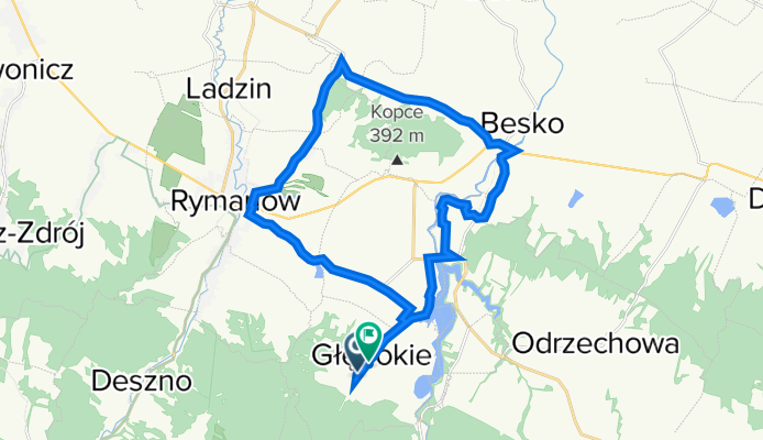
Głębokie 242A, Głębokie do Głębokie 180, Głębokie
A cycling route starting in Sieniawa, Subcarpathian Voivodeship, Poland.
Overview
About this route
- 1 h 3 min
- Duration
- 23.8 km
- Distance
- 213 m
- Ascent
- 237 m
- Descent
- 22.5 km/h
- Avg. speed
- 405 m
- Max. altitude
Route quality
Waytypes & surfaces along the route
Waytypes
Road
11.2 km
(47 %)
Quiet road
8.8 km
(37 %)
Surfaces
Paved
20.6 km
(86 %)
Asphalt
20.3 km
(85 %)
Paving stones
0.3 km
(1 %)
Undefined
3.2 km
(14 %)
Continue with Bikemap
Use, edit, or download this cycling route
You would like to ride Głębokie 242A, Głębokie do Głębokie 180, Głębokie or customize it for your own trip? Here is what you can do with this Bikemap route:
Free features
- Save this route as favorite or in collections
- Copy & plan your own version of this route
- Sync your route with Garmin or Wahoo
Premium features
Free trial for 3 days, or one-time payment. More about Bikemap Premium.
- Navigate this route on iOS & Android
- Export a GPX / KML file of this route
- Create your custom printout (try it for free)
- Download this route for offline navigation
Discover more Premium features.
Get Bikemap PremiumFrom our community
Other popular routes starting in Sieniawa
 Puławy-Tokarnia-Bukowsko
- Distance
- 40 km
- Ascent
- 554 m
- Descent
- 584 m
- Location
- Sieniawa, Subcarpathian Voivodeship, Poland
 Beskid Niski #2
- Distance
- 249.3 km
- Ascent
- 5,039 m
- Descent
- 5,041 m
- Location
- Sieniawa, Subcarpathian Voivodeship, Poland
 puławy
- Distance
- 14.6 km
- Ascent
- 486 m
- Descent
- 480 m
- Location
- Sieniawa, Subcarpathian Voivodeship, Poland
 Beskid niski
- Distance
- 180.5 km
- Ascent
- 1,767 m
- Descent
- 1,777 m
- Location
- Sieniawa, Subcarpathian Voivodeship, Poland
 2011.08.06 wisłoczek
- Distance
- 47.6 km
- Ascent
- 881 m
- Descent
- 881 m
- Location
- Sieniawa, Subcarpathian Voivodeship, Poland
 Tarnawka - Rymanów-Zdrój - Cergowa - Jaśliska - Polany Surowicze - Tarnawka
- Distance
- 52.7 km
- Ascent
- 1,135 m
- Descent
- 1,136 m
- Location
- Sieniawa, Subcarpathian Voivodeship, Poland
 Puławy (zielony szlak) Wisłok wielki - Tokarnia (Żółty Szlak) - Puławy górne (czerwony)
- Distance
- 35.4 km
- Ascent
- 906 m
- Descent
- 902 m
- Location
- Sieniawa, Subcarpathian Voivodeship, Poland
 Beskid Niski 2016
- Distance
- 59.8 km
- Ascent
- 885 m
- Descent
- 885 m
- Location
- Sieniawa, Subcarpathian Voivodeship, Poland
Open it in the app