

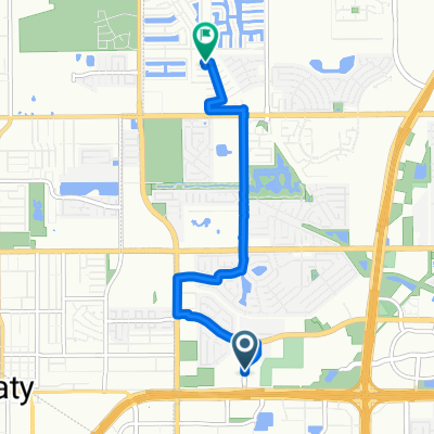
Recovered Route
A cycling route starting in Katy, Texas, United States.
Overview
About this route
- 39 min
- Duration
- 10.8 km
- Distance
- 31 m
- Ascent
- 25 m
- Descent
- 16.5 km/h
- Avg. speed
- 51 m
- Max. altitude
Continue with Bikemap
Use, edit, or download this cycling route
You would like to ride Recovered Route or customize it for your own trip? Here is what you can do with this Bikemap route:
Free features
- Save this route as favorite or in collections
- Copy & plan your own version of this route
- Sync your route with Garmin or Wahoo
Premium features
Free trial for 3 days, or one-time payment. More about Bikemap Premium.
- Navigate this route on iOS & Android
- Export a GPX / KML file of this route
- Create your custom printout (try it for free)
- Download this route for offline navigation
Discover more Premium features.
Get Bikemap PremiumFrom our community
Other popular routes starting in Katy
 Katy HS -63 Miles
- Distance
- 100.8 km
- Ascent
- 172 m
- Descent
- 172 m
- Location
- Katy, Texas, United States
 28602 Blue Holly Ln, Katy to 28802 Millstead Creek Ln, Katy
- Distance
- 70.8 km
- Ascent
- 197 m
- Descent
- 195 m
- Location
- Katy, Texas, United States
 BBK Early 20 v1.1
- Distance
- 30.7 km
- Ascent
- 58 m
- Descent
- 58 m
- Location
- Katy, Texas, United States
 Birchwood Bend Court 6707, Katy to Carlise Hills Trace 23602, Katy
- Distance
- 7.8 km
- Ascent
- 38 m
- Descent
- 42 m
- Location
- Katy, Texas, United States
 De Katy Freeway a Rossi Gardens Circle
- Distance
- 7.3 km
- Ascent
- 44 m
- Descent
- 7 m
- Location
- Katy, Texas, United States
 De Rossi Gardens Circle a South Mason Road
- Distance
- 17.3 km
- Ascent
- 63 m
- Descent
- 42 m
- Location
- Katy, Texas, United States
 Katy to Lubbock
- Distance
- 922.3 km
- Ascent
- 3,791 m
- Descent
- 2,855 m
- Location
- Katy, Texas, United States
 Forest Pass Ln, Katy to 27214–27250 Fulshear Bend Dr, Fulshear
- Distance
- 4.3 km
- Ascent
- 4 m
- Descent
- 4 m
- Location
- Katy, Texas, United States
Open it in the app