

Conoma 2
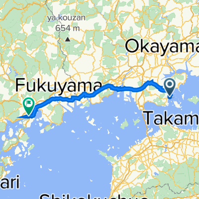
A cycling route starting in Tamano, Okayama, Japan.
Overview
About this route
- -:--
- Duration
- 16.8 km
- Distance
- 120 m
- Ascent
- 156 m
- Descent
- ---
- Avg. speed
- 43 m
- Max. altitude
Route quality
Waytypes & surfaces along the route
Waytypes
Quiet road
7.9 km
(47 %)
Cycleway
4.7 km
(28 %)
Surfaces
Paved
4.7 km
(28 %)
Asphalt
4.7 km
(28 %)
Undefined
12.1 km
(72 %)
Continue with Bikemap
Use, edit, or download this cycling route
You would like to ride Conoma 2 or customize it for your own trip? Here is what you can do with this Bikemap route:
Free features
- Save this route as favorite or in collections
- Copy & plan your own version of this route
- Sync your route with Garmin or Wahoo
Premium features
Free trial for 3 days, or one-time payment. More about Bikemap Premium.
- Navigate this route on iOS & Android
- Export a GPX / KML file of this route
- Create your custom printout (try it for free)
- Download this route for offline navigation
Discover more Premium features.
Get Bikemap PremiumFrom our community
Other popular routes starting in Tamano
 tamano - onomichi
- Distance
- 86.1 km
- Ascent
- 543 m
- Descent
- 549 m
- Location
- Tamano, Okayama, Japan
 県道21号, 倉敷市 to 柳川筋, 岡山市北区
- Distance
- 31.4 km
- Ascent
- 193 m
- Descent
- 191 m
- Location
- Tamano, Okayama, Japan
 2022-09-03 A quick morning ride.
- Distance
- 6.3 km
- Ascent
- 117 m
- Descent
- 119 m
- Location
- Tamano, Okayama, Japan
 sample
- Distance
- 1.6 km
- Ascent
- 59 m
- Descent
- 58 m
- Location
- Tamano, Okayama, Japan
 Dentist
- Distance
- 8.2 km
- Ascent
- 109 m
- Descent
- 146 m
- Location
- Tamano, Okayama, Japan
 Kojima Kaze no Michi loop
- Distance
- 7.7 km
- Ascent
- 165 m
- Descent
- 158 m
- Location
- Tamano, Okayama, Japan
 2022-08-14 Ride around town
- Distance
- 15.1 km
- Ascent
- 72 m
- Descent
- 74 m
- Location
- Tamano, Okayama, Japan
 Conoma 2
- Distance
- 16.8 km
- Ascent
- 120 m
- Descent
- 156 m
- Location
- Tamano, Okayama, Japan
Open it in the app