
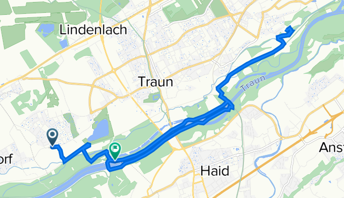
Steinweg 21, Traun nach 664F+8P, Traun
A cycling route starting in Traun, Upper Austria, Austria.
Overview
About this route
- 40 min
- Duration
- 13.8 km
- Distance
- 67 m
- Ascent
- 68 m
- Descent
- 20.6 km/h
- Avg. speed
- 277 m
- Avg. speed

Route quality
Waytypes & surfaces along the route
Waytypes
Cycleway
8.6 km
(62 %)
Track
1.7 km
(12 %)
Surfaces
Paved
11.4 km
(83 %)
Unpaved
1.5 km
(11 %)
Asphalt
11.2 km
(81 %)
Gravel
0.8 km
(6 %)
Continue with Bikemap
Use, edit, or download this cycling route
You would like to ride Steinweg 21, Traun nach 664F+8P, Traun or customize it for your own trip? Here is what you can do with this Bikemap route:
Free features
- Save this route as favorite or in collections
- Copy & plan your own version of this route
- Sync your route with Garmin or Wahoo
Premium features
Free trial for 3 days, or one-time payment. More about Bikemap Premium.
- Navigate this route on iOS & Android
- Export a GPX / KML file of this route
- Create your custom printout (try it for free)
- Download this route for offline navigation
Discover more Premium features.
Get Bikemap PremiumFrom our community
Other popular routes starting in Traun
 Schloßstraße 48a, Traun nach Doblerholz, Leonding
- Distance
- 6 km
- Ascent
- 55 m
- Descent
- 18 m
- Location
- Traun, Upper Austria, Austria
 Marchtrenk Runde
- Distance
- 24.9 km
- Ascent
- 47 m
- Descent
- 42 m
- Location
- Traun, Upper Austria, Austria
 Stifterstraße 2, Traun nach Leondinger Straße 39, Traun
- Distance
- 10.3 km
- Ascent
- 100 m
- Descent
- 97 m
- Location
- Traun, Upper Austria, Austria
 Traun goes Mühlviertel
- Distance
- 71.4 km
- Ascent
- 1,202 m
- Descent
- 1,190 m
- Location
- Traun, Upper Austria, Austria
 mit damili
- Distance
- 10.4 km
- Ascent
- 280 m
- Descent
- 288 m
- Location
- Traun, Upper Austria, Austria
 Nettingsdorf Ebersberg Ansfelden
- Distance
- 23.9 km
- Ascent
- 106 m
- Descent
- 107 m
- Location
- Traun, Upper Austria, Austria
 Traun-Ansfelden-Marchtrenk-Traun
- Distance
- 41.8 km
- Ascent
- 304 m
- Descent
- 297 m
- Location
- Traun, Upper Austria, Austria
 Traun-Gmunden R4
- Distance
- 57.8 km
- Ascent
- 284 m
- Descent
- 128 m
- Location
- Traun, Upper Austria, Austria
Open it in the app