

France2023 E5
A cycling route starting in Saint-Apollinaire, Bourgogne-Franche-Comté, France.
Overview
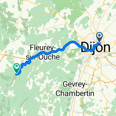
About this route
Dijon - Chalon-sur-Saône
- -:--
- Duration
- 85.8 km
- Distance
- 435 m
- Ascent
- 494 m
- Descent
- ---
- Avg. speed
- 301 m
- Max. altitude

Route quality
Waytypes & surfaces along the route
Waytypes
Quiet road
35.2 km
(41 %)
Road
28.3 km
(33 %)
Surfaces
Paved
66.1 km
(77 %)
Asphalt
65.2 km
(76 %)
Paved (undefined)
0.9 km
(1 %)
Undefined
19.7 km
(23 %)
Continue with Bikemap
Use, edit, or download this cycling route
You would like to ride France2023 E5 or customize it for your own trip? Here is what you can do with this Bikemap route:
Free features
- Save this route as favorite or in collections
- Copy & plan your own version of this route
- Split it into stages to create a multi-day tour
- Sync your route with Garmin or Wahoo
Premium features
Free trial for 3 days, or one-time payment. More about Bikemap Premium.
- Navigate this route on iOS & Android
- Export a GPX / KML file of this route
- Create your custom printout (try it for free)
- Download this route for offline navigation
Discover more Premium features.
Get Bikemap PremiumFrom our community
Other popular routes starting in Saint-Apollinaire
 Bignol 42 km
- Distance
- 42 km
- Ascent
- 286 m
- Descent
- 283 m
- Location
- Saint-Apollinaire, Bourgogne-Franche-Comté, France
 From Dijon to Gissey-sur-Ouche
- Distance
- 30.9 km
- Ascent
- 171 m
- Descent
- 120 m
- Location
- Saint-Apollinaire, Bourgogne-Franche-Comté, France
 Dijon - Ahuy - Messine et vantoux - Asnières les Dijon - Dijon
- Distance
- 22.2 km
- Ascent
- 106 m
- Descent
- 108 m
- Location
- Saint-Apollinaire, Bourgogne-Franche-Comté, France
 Dijon_links zum Kanal 50 km
- Distance
- 50.8 km
- Ascent
- 295 m
- Descent
- 291 m
- Location
- Saint-Apollinaire, Bourgogne-Franche-Comté, France
 Dijon Turcey Bussy Pasques Dijon
- Distance
- 100.2 km
- Ascent
- 750 m
- Descent
- 750 m
- Location
- Saint-Apollinaire, Bourgogne-Franche-Comté, France
 BOURGOGNE Côte d'or - Randonnée des sources (21)
- Distance
- 157.8 km
- Ascent
- 1,193 m
- Descent
- 1,194 m
- Location
- Saint-Apollinaire, Bourgogne-Franche-Comté, France
 DIJON - CHAMPS /Marne
- Distance
- 447 km
- Ascent
- 367 m
- Descent
- 572 m
- Location
- Saint-Apollinaire, Bourgogne-Franche-Comté, France
 2009 Euro Tour -- Ride Day 15 — 9 July 2009 — 21850 St-Apollinaire (Dijon) to 89200 Magny (Avallon)
- Distance
- 119.3 km
- Ascent
- 628 m
- Descent
- 635 m
- Location
- Saint-Apollinaire, Bourgogne-Franche-Comté, France
Open it in the app