Familienradler 2025 4. Tag
- 56.2 km
- 244 m
- 254 m
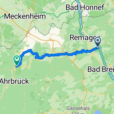
- Linz am Rhein, Rhineland-Palatinate, Germany
A cycling route starting in Linz am Rhein, Rhineland-Palatinate, Germany.
Overview
Start at Kripp Johannesweg parking lot, Ahr cycle path, in Bad Bodendorf over the Ahr bridge, Heimersheim, at Heppingen over the Ahr, Bad Neuenahr, Ahr bridge, Bachem, Ahr bridge, Ahrweiler, cemetery, Walporzheim, Bunte Kuh, Marienthal monastery, bunker, from here the only climb through the forest, panoramic view, vineyard path to Försterhof, stop here at wine terraces, Altenwegshof, descent into the valley, Silberberg, passing the Roman villa, crossing B267, Ahrweiler, rest at the market square, cemetery, Ahr riverside cycle path, Bad Neuenahr, behind Bad Neuenahr same way back as outward journey to Kripp.
created this 3 years ago
Route quality
Quiet road
11 km
(28 %)
Track
7.5 km
(19 %)
Paved
28.8 km
(73 %)
Unpaved
5.5 km
(14 %)
Asphalt
28 km
(71 %)
Ground
2.4 km
(6 %)
Continue with Bikemap
You would like to ride Kripp-Marienthal-Försterhof-Kripp 40 km 210 Hm or customize it for your own trip? Here is what you can do with this Bikemap route:
Free trial for 3 days, or one-time payment. More about Bikemap Premium.
Discover more Premium features.
Get Bikemap PremiumFrom our community
Open it in the app