

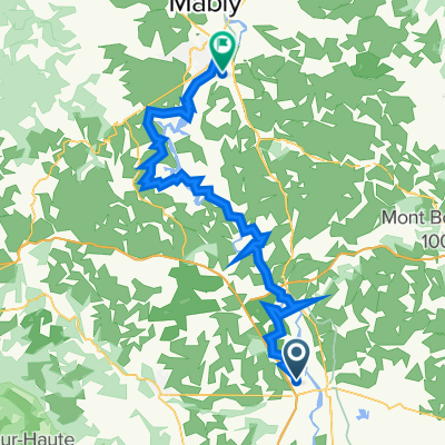
LV06 Feurs to Roanne.kml - LV06 Feurs to Roanne.kml_LV06 Feurs to Roanne
A cycling route starting in Feurs, Auvergne-Rhône-Alpes, France.
Overview
About this route
Converted from a KML file KML2GPX.COM - This is track no: 1
- -:--
- Duration
- 63.3 km
- Distance
- 875 m
- Ascent
- 945 m
- Descent
- ---
- Avg. speed
- 484 m
- Avg. speed

Route quality
Waytypes & surfaces along the route
Waytypes
Busy road
23.7 km
(37 %)
Road
20.7 km
(33 %)
Surfaces
Paved
15.4 km
(24 %)
Asphalt
15.4 km
(24 %)
Undefined
47.9 km
(76 %)
Continue with Bikemap
Use, edit, or download this cycling route
You would like to ride LV06 Feurs to Roanne.kml - LV06 Feurs to Roanne.kml_LV06 Feurs to Roanne or customize it for your own trip? Here is what you can do with this Bikemap route:
Free features
- Save this route as favorite or in collections
- Copy & plan your own version of this route
- Sync your route with Garmin or Wahoo
Premium features
Free trial for 3 days, or one-time payment. More about Bikemap Premium.
- Navigate this route on iOS & Android
- Export a GPX / KML file of this route
- Create your custom printout (try it for free)
- Download this route for offline navigation
Discover more Premium features.
Get Bikemap PremiumFrom our community
Other popular routes starting in Feurs
 Feurs St Etienne Le Rhône
- Distance
- 98.2 km
- Ascent
- 903 m
- Descent
- 1,109 m
- Location
- Feurs, Auvergne-Rhône-Alpes, France
 Le Frog Day 7
- Distance
- 144 km
- Ascent
- 749 m
- Descent
- 979 m
- Location
- Feurs, Auvergne-Rhône-Alpes, France
 De 6 Impasse du Grand Pré, Feurs à 6 Impasse du Grand Pré, Feurs
- Distance
- 6.3 km
- Ascent
- 36 m
- Descent
- 35 m
- Location
- Feurs, Auvergne-Rhône-Alpes, France
 LV06 Feurs to Roanne.kml - LV06 Feurs to Roanne.kml_LV06 Feurs to Roanne
- Distance
- 63.3 km
- Ascent
- 875 m
- Descent
- 945 m
- Location
- Feurs, Auvergne-Rhône-Alpes, France
 Feurs to valence
- Distance
- 150.4 km
- Ascent
- 769 m
- Descent
- 995 m
- Location
- Feurs, Auvergne-Rhône-Alpes, France
 240 Rue du Palais, Civens nach 2–18 Rue du Vieux Puits, Bas-en-Basset
- Distance
- 64.1 km
- Ascent
- 593 m
- Descent
- 472 m
- Location
- Feurs, Auvergne-Rhône-Alpes, France
 1–999 Chemin de Sainte-Anne, Valeille à 146F Route de Virigneux, Saint-Cyr-les-Vignes
- Distance
- 28.2 km
- Ascent
- 68 m
- Descent
- 52 m
- Location
- Feurs, Auvergne-Rhône-Alpes, France
 L2: Cleppe-Naconne - La Coteau; 70,3km 760hm
- Distance
- 70.3 km
- Ascent
- 849 m
- Descent
- 903 m
- Location
- Feurs, Auvergne-Rhône-Alpes, France
Open it in the app