

LV17 Beaugency to Blois.kml - LV17 Beaugency to Blois.kml_LV17 Beaugency to Blois
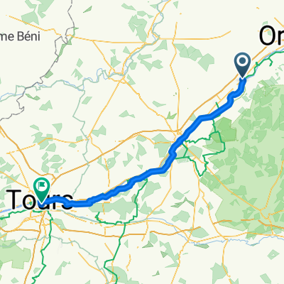
A cycling route starting in Beaugency, Centre-Val de Loire, France.
Overview
About this route
Converted from a KML file KML2GPX.COM - This is track no: 1
- -:--
- Duration
- 34.7 km
- Distance
- 71 m
- Ascent
- 88 m
- Descent
- ---
- Avg. speed
- 92 m
- Max. altitude

Route quality
Waytypes & surfaces along the route
Waytypes
Quiet road
14.6 km
(42 %)
Cycleway
6.9 km
(20 %)
Surfaces
Paved
12.2 km
(35 %)
Unpaved
10.8 km
(31 %)
Asphalt
10.4 km
(30 %)
Gravel
6.9 km
(20 %)
Continue with Bikemap
Use, edit, or download this cycling route
You would like to ride LV17 Beaugency to Blois.kml - LV17 Beaugency to Blois.kml_LV17 Beaugency to Blois or customize it for your own trip? Here is what you can do with this Bikemap route:
Free features
- Save this route as favorite or in collections
- Copy & plan your own version of this route
- Sync your route with Garmin or Wahoo
Premium features
Free trial for 3 days, or one-time payment. More about Bikemap Premium.
- Navigate this route on iOS & Android
- Export a GPX / KML file of this route
- Create your custom printout (try it for free)
- Download this route for offline navigation
Discover more Premium features.
Get Bikemap PremiumFrom our community
Other popular routes starting in Beaugency
 LV17 Beaugency to Blois.kml - LV17 Beaugency to Blois.kml_LV17 Beaugency to Blois
- Distance
- 34.7 km
- Ascent
- 71 m
- Descent
- 88 m
- Location
- Beaugency, Centre-Val de Loire, France
 Route to Amboise
- Distance
- 79.4 km
- Ascent
- 346 m
- Descent
- 373 m
- Location
- Beaugency, Centre-Val de Loire, France
 Loire Radweg: Tag 2 Beaugency - Cheverny
- Distance
- 58.7 km
- Ascent
- 169 m
- Descent
- 181 m
- Location
- Beaugency, Centre-Val de Loire, France
 Day 6
Day 6- Distance
- 40.2 km
- Ascent
- 71 m
- Descent
- 85 m
- Location
- Beaugency, Centre-Val de Loire, France
 E10 Beaugency - Amboise
- Distance
- 76.8 km
- Ascent
- 306 m
- Descent
- 335 m
- Location
- Beaugency, Centre-Val de Loire, France
 Beaugency / Chambord
- Distance
- 33.1 km
- Ascent
- 69 m
- Descent
- 74 m
- Location
- Beaugency, Centre-Val de Loire, France
 2020 04 Beaugency-Tours
- Distance
- 102.7 km
- Ascent
- 144 m
- Descent
- 192 m
- Location
- Beaugency, Centre-Val de Loire, France
 6) Beaugency - Sully/Loire
- Distance
- 80.3 km
- Ascent
- 115 m
- Descent
- 87 m
- Location
- Beaugency, Centre-Val de Loire, France
Open it in the app