
Rond om s Studeland
A cycling route starting in Klingnau, Canton of Aargau, Switzerland.
Overview
About this route
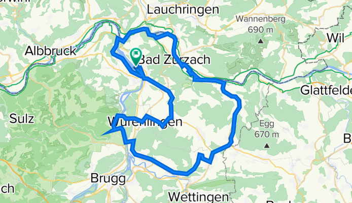
Klingnau-Reservoir-Koblenz-Zurzach-Melikon-Schneisingen-Hertenstein-Villigen-Endingen-Klingnau
- -:--
- Duration
- 63.6 km
- Distance
- 619 m
- Ascent
- 619 m
- Descent
- ---
- Avg. speed
- 506 m
- Max. altitude
Route quality
Waytypes & surfaces along the route
Waytypes
Quiet road
24.2 km
(38 %)
Track
13.4 km
(21 %)
Surfaces
Paved
53.4 km
(84 %)
Unpaved
4.5 km
(7 %)
Asphalt
52.2 km
(82 %)
Gravel
3.8 km
(6 %)
Continue with Bikemap
Use, edit, or download this cycling route
You would like to ride Rond om s Studeland or customize it for your own trip? Here is what you can do with this Bikemap route:
Free features
- Save this route as favorite or in collections
- Copy & plan your own version of this route
- Sync your route with Garmin or Wahoo
Premium features
Free trial for 3 days, or one-time payment. More about Bikemap Premium.
- Navigate this route on iOS & Android
- Export a GPX / KML file of this route
- Create your custom printout (try it for free)
- Download this route for offline navigation
Discover more Premium features.
Get Bikemap PremiumFrom our community
Other popular routes starting in Klingnau
 Feldberg ü Schluchsee
- Distance
- 118.4 km
- Ascent
- 1,734 m
- Descent
- 1,735 m
- Location
- Klingnau, Canton of Aargau, Switzerland
 X Bad Säckingen
- Distance
- 70 km
- Ascent
- 598 m
- Descent
- 605 m
- Location
- Klingnau, Canton of Aargau, Switzerland
 Donauesch-knapp180 aufwärts1340
- Distance
- 177.9 km
- Ascent
- 832 m
- Descent
- 800 m
- Location
- Klingnau, Canton of Aargau, Switzerland
 145km Loop Around Airport
- Distance
- 150.7 km
- Ascent
- 494 m
- Descent
- 493 m
- Location
- Klingnau, Canton of Aargau, Switzerland
 Schopfa-Schdaufa-Bölcha
- Distance
- 208.5 km
- Ascent
- 2,432 m
- Descent
- 2,433 m
- Location
- Klingnau, Canton of Aargau, Switzerland
 Husum A1 ET 1+2
- Distance
- 325.1 km
- Ascent
- 73 m
- Descent
- 278 m
- Location
- Klingnau, Canton of Aargau, Switzerland
 BG-73
BG-73- Distance
- 73.1 km
- Ascent
- 1,049 m
- Descent
- 1,052 m
- Location
- Klingnau, Canton of Aargau, Switzerland
 Gippingen - Ride - 9 Jun 2013
- Distance
- 53.5 km
- Ascent
- 590 m
- Descent
- 590 m
- Location
- Klingnau, Canton of Aargau, Switzerland
Open it in the app