

Hammer Blick 🤠 – Aussichtsturm Fünf-Seen-Blick Runde von Föhren - Hammer Blick 🤠 – Aussichtsturm Fünf-Seen-Blick Runde von Föhren
A cycling route starting in Bekond, Rhineland-Palatinate, Germany.
Overview
About this route
- -:--
- Duration
- 35.1 km
- Distance
- 901 m
- Ascent
- 902 m
- Descent
- ---
- Avg. speed
- 444 m
- Max. altitude

Route quality
Waytypes & surfaces along the route
Waytypes
Track
20.3 km
(58 %)
Path
5 km
(14 %)
Surfaces
Paved
19.7 km
(56 %)
Unpaved
13.6 km
(39 %)
Asphalt
13.8 km
(39 %)
Gravel
9.6 km
(27 %)
Continue with Bikemap
Use, edit, or download this cycling route
You would like to ride Hammer Blick 🤠 – Aussichtsturm Fünf-Seen-Blick Runde von Föhren - Hammer Blick 🤠 – Aussichtsturm Fünf-Seen-Blick Runde von Föhren or customize it for your own trip? Here is what you can do with this Bikemap route:
Free features
- Save this route as favorite or in collections
- Copy & plan your own version of this route
- Sync your route with Garmin or Wahoo
Premium features
Free trial for 3 days, or one-time payment. More about Bikemap Premium.
- Navigate this route on iOS & Android
- Export a GPX / KML file of this route
- Create your custom printout (try it for free)
- Download this route for offline navigation
Discover more Premium features.
Get Bikemap PremiumFrom our community
Other popular routes starting in Bekond
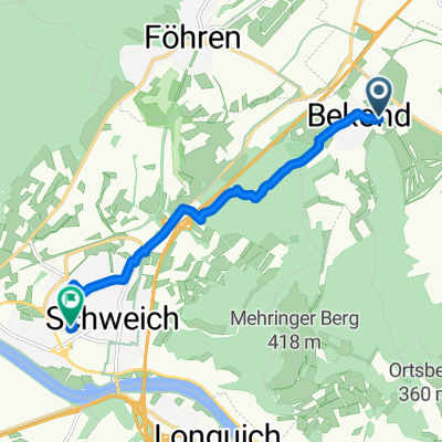 Moselstraße, Bekond nach Im Ermesgraben, Schweich
- Distance
- 7.3 km
- Ascent
- 48 m
- Descent
- 125 m
- Location
- Bekond, Rhineland-Palatinate, Germany
 Moselstraße 55A nach Moselstraße 55A
- Distance
- 37.2 km
- Ascent
- 634 m
- Descent
- 695 m
- Location
- Bekond, Rhineland-Palatinate, Germany
 Hammer Blick 🤠 – Aussichtsturm Fünf-Seen-Blick Runde von Föhren - Hammer Blick 🤠 – Aussichtsturm Fünf-Seen-Blick Runde von Föhren
- Distance
- 35.1 km
- Ascent
- 901 m
- Descent
- 902 m
- Location
- Bekond, Rhineland-Palatinate, Germany
 Bekond-Meulenwald-Quint-Schweich-Bekond
- Distance
- 31.7 km
- Ascent
- 673 m
- Descent
- 674 m
- Location
- Bekond, Rhineland-Palatinate, Germany
 Route nach Hochkreuz 1, 54343 Föhren
- Distance
- 0.9 km
- Ascent
- 4 m
- Descent
- 0 m
- Location
- Bekond, Rhineland-Palatinate, Germany
 Bekond - Schweich - Thörnicher Ritsch - Bekond
- Distance
- 24.2 km
- Ascent
- 187 m
- Descent
- 198 m
- Location
- Bekond, Rhineland-Palatinate, Germany
 Weinbergstraße nach Moselstraße
- Distance
- 18.3 km
- Ascent
- 348 m
- Descent
- 442 m
- Location
- Bekond, Rhineland-Palatinate, Germany
 Kieskaule und Mosel Tour
- Distance
- 32.5 km
- Ascent
- 244 m
- Descent
- 240 m
- Location
- Bekond, Rhineland-Palatinate, Germany
Open it in the app