

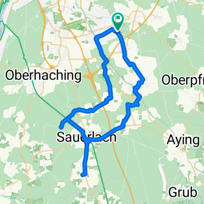
CaffeeMomm
A cycling route starting in Hohenbrunn, Bavaria, Germany.
Overview
About this route
- -:--
- Duration
- 22.9 km
- Distance
- 103 m
- Ascent
- 106 m
- Descent
- ---
- Avg. speed
- 605 m
- Max. altitude

Route quality
Waytypes & surfaces along the route
Waytypes
Path
10.5 km
(46 %)
Quiet road
5 km
(22 %)
Surfaces
Paved
18.6 km
(81 %)
Unpaved
3.9 km
(17 %)
Asphalt
18.6 km
(81 %)
Pebblestone
2.7 km
(12 %)
Route highlights
Points of interest along the route
Point of interest after 0 km
ZUHAUSE
Continue with Bikemap
Use, edit, or download this cycling route
You would like to ride CaffeeMomm or customize it for your own trip? Here is what you can do with this Bikemap route:
Free features
- Save this route as favorite or in collections
- Copy & plan your own version of this route
- Sync your route with Garmin or Wahoo
Premium features
Free trial for 3 days, or one-time payment. More about Bikemap Premium.
- Navigate this route on iOS & Android
- Export a GPX / KML file of this route
- Create your custom printout (try it for free)
- Download this route for offline navigation
Discover more Premium features.
Get Bikemap PremiumFrom our community
Other popular routes starting in Hohenbrunn
 Zeitgeist Arget
- Distance
- 17.7 km
- Ascent
- 103 m
- Descent
- 17 m
- Location
- Hohenbrunn, Bavaria, Germany
 Hohenbrunn to GrasserStrasse
- Distance
- 21.9 km
- Ascent
- 17 m
- Descent
- 66 m
- Location
- Hohenbrunn, Bavaria, Germany
 Walchensee über Sylvestern Stausee
- Distance
- 129.9 km
- Ascent
- 581 m
- Descent
- 333 m
- Location
- Hohenbrunn, Bavaria, Germany
 Aying und zurück
- Distance
- 27.3 km
- Ascent
- 193 m
- Descent
- 202 m
- Location
- Hohenbrunn, Bavaria, Germany
 Lange Oberlandrunde
- Distance
- 44.7 km
- Ascent
- 1,348 m
- Descent
- 1,035 m
- Location
- Hohenbrunn, Bavaria, Germany
 St. Anna Sauerlach
- Distance
- 44.5 km
- Ascent
- 235 m
- Descent
- 232 m
- Location
- Hohenbrunn, Bavaria, Germany
 CaffeeMomm
- Distance
- 22.9 km
- Ascent
- 103 m
- Descent
- 106 m
- Location
- Hohenbrunn, Bavaria, Germany
 Moderate Route in Hohenbrunn
- Distance
- 10.8 km
- Ascent
- 604 m
- Descent
- 553 m
- Location
- Hohenbrunn, Bavaria, Germany
Open it in the app