
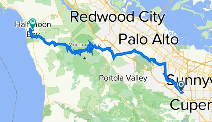
1235 Monte Verde Ct, Los Altos to 508 Main St, Half Moon Bay
A cycling route starting in Loyola, California, United States of America.
Overview
About this route
- 3 h 50 min
- Duration
- 51 km
- Distance
- 1,294 m
- Ascent
- 1,354 m
- Descent
- 13.3 km/h
- Avg. speed
- 673 m
- Max. altitude

Route quality
Waytypes & surfaces along the route
Waytypes
Road
20.5 km
(40 %)
Busy road
12 km
(24 %)
Surfaces
Paved
32.5 km
(64 %)
Unpaved
0.5 km
(<1 %)
Asphalt
32.4 km
(64 %)
Ground
0.5 km
(<1 %)
Continue with Bikemap
Use, edit, or download this cycling route
You would like to ride 1235 Monte Verde Ct, Los Altos to 508 Main St, Half Moon Bay or customize it for your own trip? Here is what you can do with this Bikemap route:
Free features
- Save this route as favorite or in collections
- Copy & plan your own version of this route
- Sync your route with Garmin or Wahoo
Premium features
Free trial for 3 days, or one-time payment. More about Bikemap Premium.
- Navigate this route on iOS & Android
- Export a GPX / KML file of this route
- Create your custom printout (try it for free)
- Download this route for offline navigation
Discover more Premium features.
Get Bikemap PremiumFrom our community
Other popular routes starting in Loyola
 T33 Stevens Canyon Loop
- Distance
- 42.6 km
- Ascent
- 775 m
- Descent
- 757 m
- Location
- Loyola, California, United States of America
 Coyote Trail, Los Altos to Permanente Creek Trail, Los Altos
- Distance
- 2 km
- Ascent
- 20 m
- Descent
- 42 m
- Location
- Loyola, California, United States of America
 Grizzly Flat
- Distance
- 114.5 km
- Ascent
- 1,984 m
- Descent
- 1,788 m
- Location
- Loyola, California, United States of America
 Los Altos Hills plus
- Distance
- 12.3 km
- Ascent
- 218 m
- Descent
- 218 m
- Location
- Loyola, California, United States of America
 ride from Los Altos to Los Gatos
- Distance
- 35 km
- Ascent
- 124 m
- Descent
- 99 m
- Location
- Loyola, California, United States of America
 Orangetree Lane to New Alta Housing HQ
- Distance
- 15.7 km
- Ascent
- 5 m
- Descent
- 51 m
- Location
- Loyola, California, United States of America
 Top of page mill
- Distance
- 24.9 km
- Ascent
- 678 m
- Descent
- 69 m
- Location
- Loyola, California, United States of America
 Stevens Canyon
- Distance
- 19 km
- Ascent
- 398 m
- Descent
- 125 m
- Location
- Loyola, California, United States of America
Open it in the app