
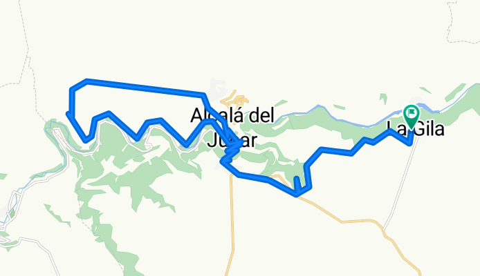
La Gila - El Cerro - Alcala del Jucar - Las Eras
A cycling route starting in Alcalá del Júcar, Castille-La Mancha, Spain.
Overview
About this route
Parcours VTT avec une belle "bajada" descente dans les rues étroites de Alcala del jucar.
- -:--
- Duration
- 31.1 km
- Distance
- 395 m
- Ascent
- 395 m
- Descent
- ---
- Avg. speed
- ---
- Max. altitude
Continue with Bikemap
Use, edit, or download this cycling route
You would like to ride La Gila - El Cerro - Alcala del Jucar - Las Eras or customize it for your own trip? Here is what you can do with this Bikemap route:
Free features
- Save this route as favorite or in collections
- Copy & plan your own version of this route
- Sync your route with Garmin or Wahoo
Premium features
Free trial for 3 days, or one-time payment. More about Bikemap Premium.
- Navigate this route on iOS & Android
- Export a GPX / KML file of this route
- Create your custom printout (try it for free)
- Download this route for offline navigation
Discover more Premium features.
Get Bikemap PremiumFrom our community
Other popular routes starting in Alcalá del Júcar
 La Gila - Las Rochas - Tolosa
- Distance
- 15.9 km
- Ascent
- 526 m
- Descent
- 526 m
- Location
- Alcalá del Júcar, Castille-La Mancha, Spain
 Marcha en BTT Cañones del Júcar
- Distance
- 53.4 km
- Ascent
- 730 m
- Descent
- 721 m
- Location
- Alcalá del Júcar, Castille-La Mancha, Spain
 alcala del jucar salvaje
- Distance
- 56.1 km
- Ascent
- 1,066 m
- Descent
- 1,066 m
- Location
- Alcalá del Júcar, Castille-La Mancha, Spain
 batan alcala de jucar
- Distance
- 2 km
- Ascent
- 45 m
- Descent
- 54 m
- Location
- Alcalá del Júcar, Castille-La Mancha, Spain
 B3-Alcalá del Júcar-San Clemente
- Distance
- 119.3 km
- Ascent
- 410 m
- Descent
- 227 m
- Location
- Alcalá del Júcar, Castille-La Mancha, Spain
 3 Alcala del Jucar-Almansa 67km
- Distance
- 64.9 km
- Ascent
- 683 m
- Descent
- 525 m
- Location
- Alcalá del Júcar, Castille-La Mancha, Spain
 Etapa 08_Alcalá del Júcar-Fuente Álamo
- Distance
- 80.9 km
- Ascent
- 768 m
- Descent
- 480 m
- Location
- Alcalá del Júcar, Castille-La Mancha, Spain
 La Gila - El Cerro - Alcala del Jucar - Las Eras
- Distance
- 31.1 km
- Ascent
- 395 m
- Descent
- 395 m
- Location
- Alcalá del Júcar, Castille-La Mancha, Spain
Open it in the app