

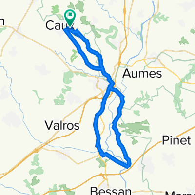
13 Chemin des Champs Suspendus, Caux à 27 Avenue de Pézenas, Caux
A cycling route starting in Caux, Occitanie, France.
Overview
About this route
- 1 h 33 min
- Duration
- 33 km
- Distance
- 256 m
- Ascent
- 282 m
- Descent
- 21.2 km/h
- Avg. speed
- 113 m
- Max. altitude
Route quality
Waytypes & surfaces along the route
Waytypes
Quiet road
16.5 km
(50 %)
Road
15.2 km
(46 %)
Surfaces
Paved
4.1 km
(12 %)
Asphalt
4.1 km
(12 %)
Undefined
29 km
(88 %)
Continue with Bikemap
Use, edit, or download this cycling route
You would like to ride 13 Chemin des Champs Suspendus, Caux à 27 Avenue de Pézenas, Caux or customize it for your own trip? Here is what you can do with this Bikemap route:
Free features
- Save this route as favorite or in collections
- Copy & plan your own version of this route
- Sync your route with Garmin or Wahoo
Premium features
Free trial for 3 days, or one-time payment. More about Bikemap Premium.
- Navigate this route on iOS & Android
- Export a GPX / KML file of this route
- Create your custom printout (try it for free)
- Download this route for offline navigation
Discover more Premium features.
Get Bikemap PremiumFrom our community
Other popular routes starting in Caux
 De ?‘Tfi? à ?‘Tfi?
- Distance
- 5.5 km
- Ascent
- 79 m
- Descent
- 80 m
- Location
- Caux, Occitanie, France
 vailhan allé retour
- Distance
- 29.4 km
- Ascent
- 244 m
- Descent
- 240 m
- Location
- Caux, Occitanie, France
 1 Impasse de la Chênaie, Caux naar 1 Impasse de la Chênaie, Caux
- Distance
- 38.2 km
- Ascent
- 218 m
- Descent
- 225 m
- Location
- Caux, Occitanie, France
 Fontes rondje Sylvie
- Distance
- 17 km
- Ascent
- 264 m
- Descent
- 264 m
- Location
- Caux, Occitanie, France
 Relaxed route in Caux
- Distance
- 24 km
- Ascent
- 142 m
- Descent
- 236 m
- Location
- Caux, Occitanie, France
 Itinéraire facile en Caux
- Distance
- 10.8 km
- Ascent
- 177 m
- Descent
- 180 m
- Location
- Caux, Occitanie, France
 4 Rue des Cigales, Caux à 5 Rue des Cigales, Caux
- Distance
- 24 km
- Ascent
- 326 m
- Descent
- 322 m
- Location
- Caux, Occitanie, France
 chiant
- Distance
- 12.5 km
- Ascent
- 106 m
- Descent
- 176 m
- Location
- Caux, Occitanie, France
Open it in the app