
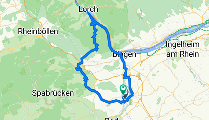
Lalo - Niederheimbach - Binger Wald - Lalo
A cycling route starting in Langenlonsheim, Rhineland-Palatinate, Germany.
Overview
About this route
null
- 7 h 22 min
- Duration
- 55.7 km
- Distance
- 641 m
- Ascent
- 579 m
- Descent
- 7.6 km/h
- Avg. speed
- 478 m
- Max. altitude

Route quality
Waytypes & surfaces along the route
Waytypes
Track
18.5 km
(33 %)
Quiet road
9.6 km
(17 %)
Surfaces
Paved
40.3 km
(72 %)
Unpaved
8 km
(14 %)
Asphalt
31.8 km
(57 %)
Paved (undefined)
5.4 km
(10 %)
Continue with Bikemap
Use, edit, or download this cycling route
You would like to ride Lalo - Niederheimbach - Binger Wald - Lalo or customize it for your own trip? Here is what you can do with this Bikemap route:
Free features
- Save this route as favorite or in collections
- Copy & plan your own version of this route
- Sync your route with Garmin or Wahoo
Premium features
Free trial for 3 days, or one-time payment. More about Bikemap Premium.
- Navigate this route on iOS & Android
- Export a GPX / KML file of this route
- Create your custom printout (try it for free)
- Download this route for offline navigation
Discover more Premium features.
Get Bikemap PremiumFrom our community
Other popular routes starting in Langenlonsheim
 Sykwalk
- Distance
- 94.8 km
- Ascent
- 732 m
- Descent
- 735 m
- Location
- Langenlonsheim, Rhineland-Palatinate, Germany
 Lauschhütte 2014
- Distance
- 52.6 km
- Ascent
- 613 m
- Descent
- 611 m
- Location
- Langenlonsheim, Rhineland-Palatinate, Germany
 Lalo - Schanzerkopf - Lalo
- Distance
- 64.8 km
- Ascent
- 1,001 m
- Descent
- 1,000 m
- Location
- Langenlonsheim, Rhineland-Palatinate, Germany
 Lalo - Münchberg - Gräfenbachtal - Lalo
- Distance
- 48.1 km
- Ascent
- 764 m
- Descent
- 766 m
- Location
- Langenlonsheim, Rhineland-Palatinate, Germany
 Hunsrück1
- Distance
- 86.1 km
- Ascent
- 1,167 m
- Descent
- 1,058 m
- Location
- Langenlonsheim, Rhineland-Palatinate, Germany
 Auf und nieder
- Distance
- 104 km
- Ascent
- 1,896 m
- Descent
- 1,837 m
- Location
- Langenlonsheim, Rhineland-Palatinate, Germany
 Eröffnung 2016
- Distance
- 67 km
- Ascent
- 697 m
- Descent
- 698 m
- Location
- Langenlonsheim, Rhineland-Palatinate, Germany
 nahe1
nahe1- Distance
- 10.1 km
- Ascent
- 62 m
- Descent
- 44 m
- Location
- Langenlonsheim, Rhineland-Palatinate, Germany
Open it in the app