

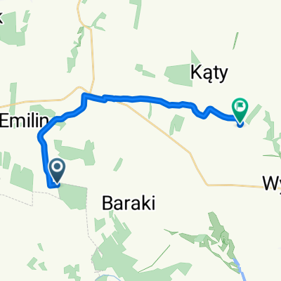
Zakrzew 94A, Zakrzew do Zakrzew 94, Zakrzew
A cycling route starting in Zakrzew, Lublin Voivodeship, Poland.
Overview
About this route
- 1 h 27 min
- Duration
- 27.2 km
- Distance
- 131 m
- Ascent
- 139 m
- Descent
- 18.7 km/h
- Avg. speed
- 279 m
- Max. altitude

Route quality
Waytypes & surfaces along the route
Waytypes
Road
22 km
(81 %)
Quiet road
1.6 km
(6 %)
Surfaces
Paved
23.9 km
(88 %)
Asphalt
23.9 km
(88 %)
Undefined
3.3 km
(12 %)
Continue with Bikemap
Use, edit, or download this cycling route
You would like to ride Zakrzew 94A, Zakrzew do Zakrzew 94, Zakrzew or customize it for your own trip? Here is what you can do with this Bikemap route:
Free features
- Save this route as favorite or in collections
- Copy & plan your own version of this route
- Sync your route with Garmin or Wahoo
Premium features
Free trial for 3 days, or one-time payment. More about Bikemap Premium.
- Navigate this route on iOS & Android
- Export a GPX / KML file of this route
- Create your custom printout (try it for free)
- Download this route for offline navigation
Discover more Premium features.
Get Bikemap PremiumFrom our community
Other popular routes starting in Zakrzew
 Zakrzew 25, Zakrzew do Zakrzew 94, Zakrzew
- Distance
- 18.4 km
- Ascent
- 106 m
- Descent
- 105 m
- Location
- Zakrzew, Lublin Voivodeship, Poland
 Ponikwy to Janowska 33, Goraj
- Distance
- 23.3 km
- Ascent
- 210 m
- Descent
- 213 m
- Location
- Zakrzew, Lublin Voivodeship, Poland
 Koncpecja szlaku rowerowego gmina Wysokie
- Distance
- 35.4 km
- Ascent
- 190 m
- Descent
- 186 m
- Location
- Zakrzew, Lublin Voivodeship, Poland
 Zakrzew 94A, Zakrzew do Zakrzew 94, Zakrzew
- Distance
- 27.2 km
- Ascent
- 131 m
- Descent
- 139 m
- Location
- Zakrzew, Lublin Voivodeship, Poland
 Annów, Zakrzew do Spławy, Wysokie
- Distance
- 12.9 km
- Ascent
- 73 m
- Descent
- 67 m
- Location
- Zakrzew, Lublin Voivodeship, Poland
 Pogranicze halicko-sandomierskie
- Distance
- 234 km
- Ascent
- 347 m
- Descent
- 480 m
- Location
- Zakrzew, Lublin Voivodeship, Poland
 Gmina Zakrzew szlak wschód - zachód
- Distance
- 23 km
- Ascent
- 133 m
- Descent
- 87 m
- Location
- Zakrzew, Lublin Voivodeship, Poland
 Koncpecja szlaku rowerowego gmina Wysokie do punktu widokowego
- Distance
- 3.4 km
- Ascent
- 47 m
- Descent
- 4 m
- Location
- Zakrzew, Lublin Voivodeship, Poland
Open it in the app