


2020 Ruta 41
- 90.6 km
- 371 m
- 370 m
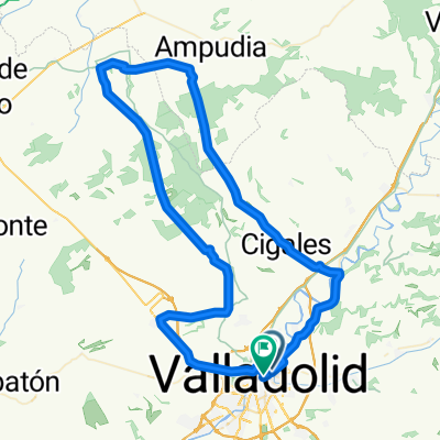
- Valladolid, Castille and León, Spain
A cycling route starting in Valladolid, Castille and León, Spain.
Overview
Pte.Mayor - Zaratan - Ciguñuela - Robladillo -Matilla -Tordesillas - Velilla - Velliza - Robladillo - Ciguñuela - Zaratan - Valladolid.
1ª Subida: Teso de AirePendiente media 4,90%Distancia 2,1 Km.
2ª Subida: Buenos AiresPendiente media 3,60%Distancia 4,4 Km.
3ª Subida. El ParamilloPendiente media 3,20%Distancia 3,5 Km.
created this 3 years ago
Route quality
Road
40.5 km
(54 %)
Quiet road
9.8 km
(13 %)
Paved
63.8 km
(85 %)
Unpaved
4.5 km
(6 %)
Asphalt
63 km
(84 %)
Gravel
2.3 km
(3 %)
Route highlights
3ª Subida. El Paramillo Pendiente media 3,20% Distancia 3,5 Km.
2ª Subida: Buenos Aires Pendiente media 3,60% Distancia 4,4 Km.
1ª Subida: Teso de Aire Pendiente media 4,90% Distancia 2,1 Km.
Continue with Bikemap
You would like to ride 2023-03-11 Ruta nº 022 or customize it for your own trip? Here is what you can do with this Bikemap route:
Free trial for 3 days, or one-time payment. More about Bikemap Premium.
Discover more Premium features.
Get Bikemap PremiumFrom our community
Open it in the app


