

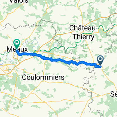
9. La Celle-Sous-Montmirail (F) - Saint-Amand-Sur-Fion (F)
A cycling route starting in Montmirail, Grand Est, France.
Overview
About this route
June 29, 2011 Valley of the river Le Petit Morin
- -:--
- Duration
- 101.9 km
- Distance
- 276 m
- Ascent
- 282 m
- Descent
- ---
- Avg. speed
- ---
- Max. altitude

Route quality
Waytypes & surfaces along the route
Waytypes
Track
21.4 km
(21 %)
Road
15.3 km
(15 %)
Surfaces
Paved
42.8 km
(42 %)
Asphalt
42.8 km
(42 %)
Undefined
59.1 km
(58 %)
Route highlights
Points of interest along the route
Point of interest after 0.6 km
Obserwacja burzy
Point of interest after 99.3 km
Continue with Bikemap
Use, edit, or download this cycling route
You would like to ride 9. La Celle-Sous-Montmirail (F) - Saint-Amand-Sur-Fion (F) or customize it for your own trip? Here is what you can do with this Bikemap route:
Free features
- Save this route as favorite or in collections
- Copy & plan your own version of this route
- Split it into stages to create a multi-day tour
- Sync your route with Garmin or Wahoo
Premium features
Free trial for 3 days, or one-time payment. More about Bikemap Premium.
- Navigate this route on iOS & Android
- Export a GPX / KML file of this route
- Create your custom printout (try it for free)
- Download this route for offline navigation
Discover more Premium features.
Get Bikemap PremiumFrom our community
Other popular routes starting in Montmirail
 Petit Morin : La vallée de l'or noir
- Distance
- 74.1 km
- Ascent
- 640 m
- Descent
- 643 m
- Location
- Montmirail, Grand Est, France
 Itinéraire à partir de Route de Paris 57-1, L'Épine-aux-Bois
- Distance
- 8.8 km
- Ascent
- 89 m
- Descent
- 88 m
- Location
- Montmirail, Grand Est, France
 Fridolfing - Paris (4-2) : Montmirail - Paris
- Distance
- 127.2 km
- Ascent
- 378 m
- Descent
- 479 m
- Location
- Montmirail, Grand Est, France
 9. La Celle-Sous-Montmirail (F) - Saint-Amand-Sur-Fion (F)
- Distance
- 101.9 km
- Ascent
- 276 m
- Descent
- 282 m
- Location
- Montmirail, Grand Est, France
 Montmirail - Meaux
- Distance
- 61.4 km
- Ascent
- 598 m
- Descent
- 728 m
- Location
- Montmirail, Grand Est, France
 retour Montmirail Sezanne
- Distance
- 30.7 km
- Ascent
- 174 m
- Descent
- 255 m
- Location
- Montmirail, Grand Est, France
 Montmirail - Sezanne MZF
- Distance
- 58.1 km
- Ascent
- 347 m
- Descent
- 406 m
- Location
- Montmirail, Grand Est, France
 PARISSSSSSSSSSS DAY16
- Distance
- 100.2 km
- Ascent
- 312 m
- Descent
- 438 m
- Location
- Montmirail, Grand Est, France
Open it in the app