
Kammtour Erzgebirge Auf dem höchsten Weg durch Sachsen und Böhmen - Kammtour Erzgebirge Auf dem höchsten Weg durch Sachsen und Böhmen
A cycling route starting in Tannenbergsthal, Saxony, Germany.
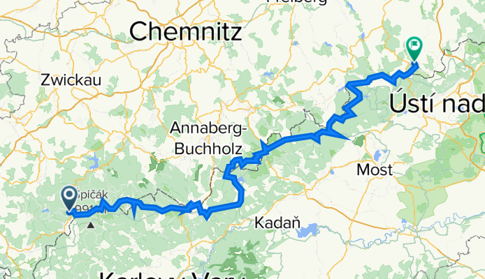
Overview
About this route
/ Auf der Kammtour erfährt sich der Radwanderer das gesamte Erzgebirge auf einer Gesamtstrecke von 166 Kilometern (Mühlleithen im Vogtland bis Altenberg im Osterzgebirge). Die Tour folgt weitestgehend dem Gebirgskamm, d.h. den höchsten Punkten des Berglandes. Die Kammtour ist waldreich, aussichtsreich und reich an interessanten Streckenpunkten, wie Ortschaften, Denkmalen, Ausflugszielen.
- -:--
- Duration
- 233.8 km
- Distance
- 2,873 m
- Ascent
- 3,132 m
- Descent
- ---
- Avg. speed
- 1,213 m
- Max. altitude

Route quality
Waytypes & surfaces along the route
Waytypes
Track
77.9 km
(33 %)
Road
74.3 km
(32 %)
Surfaces
Paved
126.6 km
(54 %)
Unpaved
64.9 km
(28 %)
Asphalt
114 km
(49 %)
Gravel
48.9 km
(21 %)
Continue with Bikemap
Use, edit, or download this cycling route
You would like to ride Kammtour Erzgebirge Auf dem höchsten Weg durch Sachsen und Böhmen - Kammtour Erzgebirge Auf dem höchsten Weg durch Sachsen und Böhmen or customize it for your own trip? Here is what you can do with this Bikemap route:
Free features
- Save this route as favorite or in collections
- Copy & plan your own version of this route
- Split it into stages to create a multi-day tour
- Sync your route with Garmin or Wahoo
Premium features
Free trial for 3 days, or one-time payment. More about Bikemap Premium.
- Navigate this route on iOS & Android
- Export a GPX / KML file of this route
- Create your custom printout (try it for free)
- Download this route for offline navigation
Discover more Premium features.
Get Bikemap PremiumFrom our community
Other popular routes starting in Tannenbergsthal
 Mühlleithen-Bublava-Brunndöbra-Mühlleithen
- Distance
- 17.8 km
- Ascent
- 427 m
- Descent
- 427 m
- Location
- Tannenbergsthal, Saxony, Germany
 Mühlleiten-Carlsfeld-Morgenröthe-Mühlleiten
- Distance
- 24 km
- Ascent
- 429 m
- Descent
- 429 m
- Location
- Tannenbergsthal, Saxony, Germany
 Gabriel-Baumann-Straße 8, Muldenhammer nach Klingenthaler Straße 3, Muldenhammer
- Distance
- 42.7 km
- Ascent
- 1,299 m
- Descent
- 1,282 m
- Location
- Tannenbergsthal, Saxony, Germany
 TBT - Klingenthal - TBT
- Distance
- 25.2 km
- Ascent
- 500 m
- Descent
- 500 m
- Location
- Tannenbergsthal, Saxony, Germany
 Kammtour Erzgebirge Auf dem höchsten Weg durch Sachsen und Böhmen - Kammtour Erzgebirge Auf dem höchsten Weg durch Sachsen und Böhmen
- Distance
- 233.8 km
- Ascent
- 2,873 m
- Descent
- 3,132 m
- Location
- Tannenbergsthal, Saxony, Germany
 Zusatz Männerstagsride zum Schneckenstein (Tannenbergsthal)
- Distance
- 9 km
- Ascent
- 231 m
- Descent
- 200 m
- Location
- Tannenbergsthal, Saxony, Germany
 Höhenmeter sammeln
- Distance
- 39.2 km
- Ascent
- 998 m
- Descent
- 963 m
- Location
- Tannenbergsthal, Saxony, Germany
 Freeride & Downhill
- Distance
- 31.9 km
- Ascent
- 1,003 m
- Descent
- 1,000 m
- Location
- Tannenbergsthal, Saxony, Germany
Open it in the app