

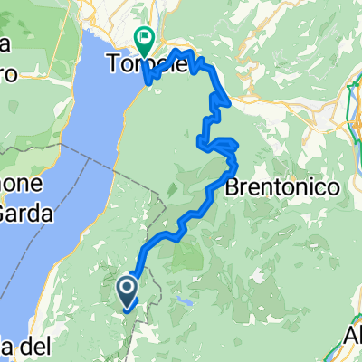
Monte Baldo Monte Altissimo Torbole
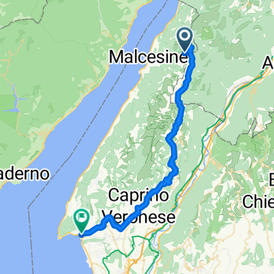
A cycling route starting in Malcesine, Veneto, Italy.
Overview
About this route
Caution at the beginning of the route, it is the cable car from Malcesine to Monte Baldo.
The last part before Torbole is very difficult to ride. It is the path 601, which is very well-known among downhillers.
- -:--
- Duration
- 63.8 km
- Distance
- 2,607 m
- Ascent
- 2,610 m
- Descent
- ---
- Avg. speed
- ---
- Max. altitude
Continue with Bikemap
Use, edit, or download this cycling route
You would like to ride Monte Baldo Monte Altissimo Torbole or customize it for your own trip? Here is what you can do with this Bikemap route:
Free features
- Save this route as favorite or in collections
- Copy & plan your own version of this route
- Sync your route with Garmin or Wahoo
Premium features
Free trial for 3 days, or one-time payment. More about Bikemap Premium.
- Navigate this route on iOS & Android
- Export a GPX / KML file of this route
- Create your custom printout (try it for free)
- Download this route for offline navigation
Discover more Premium features.
Get Bikemap PremiumFrom our community
Other popular routes starting in Malcesine
 Malcesine nach campagnola
- Distance
- 3.3 km
- Ascent
- 11 m
- Descent
- 41 m
- Location
- Malcesine, Veneto, Italy
 Malcesine-Altisimo-Malcesine
- Distance
- 47 km
- Ascent
- 2,369 m
- Descent
- 2,369 m
- Location
- Malcesine, Veneto, Italy
 Monte Baldo - Garda
- Distance
- 43.5 km
- Ascent
- 689 m
- Descent
- 2,353 m
- Location
- Malcesine, Veneto, Italy
 Monte Baldo
- Distance
- 112.9 km
- Ascent
- 1,895 m
- Descent
- 1,895 m
- Location
- Malcesine, Veneto, Italy
 Monte Baldo
- Distance
- 31.4 km
- Ascent
- 616 m
- Descent
- 2,288 m
- Location
- Malcesine, Veneto, Italy
 Via Panoramica, Malcesine nach Via Panoramica, Malcesine
- Distance
- 12.1 km
- Ascent
- 330 m
- Descent
- 325 m
- Location
- Malcesine, Veneto, Italy
 Monte Baldo_Loppio
- Distance
- 31.4 km
- Ascent
- 448 m
- Descent
- 2,122 m
- Location
- Malcesine, Veneto, Italy
 Via Panoramica, Malcesine nach Via Panoramica, Malcesine
- Distance
- 14.1 km
- Ascent
- 546 m
- Descent
- 552 m
- Location
- Malcesine, Veneto, Italy
Open it in the app