
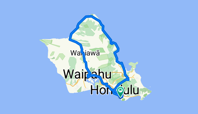
9-23 Tour de Oahu
A cycling route starting in Honolulu, Hawaii, United States.
Overview
About this route
9-23 Tour de Oahu
- -:--
- Duration
- 149.4 km
- Distance
- 721 m
- Ascent
- 735 m
- Descent
- ---
- Avg. speed
- ---
- Max. altitude
Route quality
Waytypes & surfaces along the route
Waytypes
Busy road
98.2 km
(66 %)
Road
17.6 km
(12 %)
Surfaces
Paved
114.3 km
(77 %)
Unpaved
0.4 km
(<1 %)
Asphalt
114.1 km
(76 %)
Gravel
0.3 km
(<1 %)
Route highlights
Points of interest along the route
Point of interest after 18.9 km
CP1:ヌアヌ・パリ展望台
Point of interest after 48.1 km
CP2:スワンジー・ビーチパーク
Point of interest after 69.1 km
CP3:カフク(ロミーズ)
Point of interest after 87.7 km
ラニアケアビーチ(※小休止してウミガメを探します)
Point of interest after 91.6 km
CP4:ハレイワ(マツモト・シェイブアイス)
Point of interest after 103 km
CP5:ドール・プランテーション
Point of interest after 130.9 km
CP6:アロハスタジアム
Continue with Bikemap
Use, edit, or download this cycling route
You would like to ride 9-23 Tour de Oahu or customize it for your own trip? Here is what you can do with this Bikemap route:
Free features
- Save this route as favorite or in collections
- Copy & plan your own version of this route
- Split it into stages to create a multi-day tour
- Sync your route with Garmin or Wahoo
Premium features
Free trial for 3 days, or one-time payment. More about Bikemap Premium.
- Navigate this route on iOS & Android
- Export a GPX / KML file of this route
- Create your custom printout (try it for free)
- Download this route for offline navigation
Discover more Premium features.
Get Bikemap PremiumFrom our community
Other popular routes starting in Honolulu
 Winam to Diamond Head to Kahala
- Distance
- 16.9 km
- Ascent
- 88 m
- Descent
- 88 m
- Location
- Honolulu, Hawaii, United States
 2009-07-24 Oahu circle island
- Distance
- 206.2 km
- Ascent
- 300 m
- Descent
- 303 m
- Location
- Honolulu, Hawaii, United States
 Lahona
- Distance
- 19.9 km
- Ascent
- 183 m
- Descent
- 180 m
- Location
- Honolulu, Hawaii, United States
 hawaii
- Distance
- 154.3 km
- Ascent
- 828 m
- Descent
- 826 m
- Location
- Honolulu, Hawaii, United States
 Eastern Suburbs Sufferfest
- Distance
- 109.2 km
- Ascent
- 1,709 m
- Descent
- 1,711 m
- Location
- Honolulu, Hawaii, United States
 5.Honolulu - Waipahu Ewa Beach
- Distance
- 165 km
- Ascent
- 636 m
- Descent
- 635 m
- Location
- Honolulu, Hawaii, United States
 9-23 Tour de Oahu
- Distance
- 149.4 km
- Ascent
- 721 m
- Descent
- 735 m
- Location
- Honolulu, Hawaii, United States
 Home to Diamondhead
- Distance
- 19.7 km
- Ascent
- 105 m
- Descent
- 103 m
- Location
- Honolulu, Hawaii, United States
Open it in the app